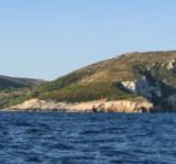
Bisevski Kanal, 2.2 miles wide, leads between Otok Bisevo and Otok Vis. This channel, in good weather, can be used to advantage to shorten the route out of the Adriatic. However, in winter with strong winds and currents it is best avoided.
2011/05/24
Update
Jojo
Bisevski Kanal, 2,2 miles de large, sépare Otok Bisevo d'Otok Vis. Ce canal, par beau temps, peut être utilisé et a l'avantage de raccourcir la route de l'Adriatique. Toutefois, en hiver avec de forts vents et des courants, il est préférable de l'éviter.
Otok Svetac (Andrija), 305m high, lies 13 miles ESE of Otocic Jabuka and is generally steep-to. The coast of the island is rocky and reddish in color on the NW side. Its SW end is fronted by a few rocks. Hrid Kamik, a dark and jagged above-water rock, lies 0.7 mile W of the SW extremity ...
Bisevo is located SW of Vis, 4 NM Komiza. This small inhabited island has an area of 5.8 sq. km. The highest point is Strazenica (239 m). The islanders live from fishing and agriculture. On its shores steep, there are many caves, the most famous is the Blue Cave (18 m long, 6 m ...
Plakeni islands, or Cursed Islands, are located at the W and S of Hvar town.
The islands are rocky, covered with bushes and trees. They are usually deserted, except in summer. They offer many choices of moorings sheltered and there is a marina Palmizana.The islands'name ...
Ciovo is an island in the center of the Dalmatian archipelago. This is an area of 28.8 acres (15.3 km length, width of 3.5 km). It culminates at 218 m (Mount Rudin). O. Ciovo forms the SW side of the entrance and inner part of Kastelanski Zaliv. At East side, Ciovo is 2km from ...
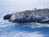
Rt Stupisce, marked by a light, is the SW extremity of the island. Brdo Hum, 587m high, stands 2.5 miles NE of this point and is the summit of the island. This conspicuous peak is bare and surmounted by a signal station.


 Bisevski Kanal, 2.2 miles wide, leads between Otok Bisevo and Otok Vis. This channel, in good weather, can be used to advantage to shorten the route out of the Adriatic. However, in winter with strong winds and currents it is best avoided.
 Bisevski Kanal, 2,2 miles de large, sépare Otok Bisevo d'Otok Vis. Ce canal, par beau temps, peut être utilisé et a l'avantage de raccourcir la route de l'Adriatique. Toutefois, en hiver avec de forts vents et des courants, il est préférable de l'éviter.