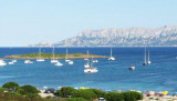
That small islet is located S Punta Casette and protects Banana cove at E. On the W side of the island there is sheltered from all winds except those of S.
The sandy and rocky bottom (4 to 5 m) is good holding.
Beware to shoal Porri (3/4 m) located about 1/2 NM S of the island.
2012/09/29
Update
Joëlle
Ce petit îlot se trouve au S de Punta Casette et protège l'anse Banana à l'E.
Sur le côté W de l'îlot on est abrité de tous les vents sauf ceux du S.
Le fond de sable (4 à 5 m) et de roches est de bonne tenue.
Attention au haut-fond dei Porri (3/4 m) situé à environ 1/2 MN au S de l'îlot.
2012/09/29
Update
Joëlle
Questo picolo isolotto si trova S Punta Casette e riparo la cala Banana all'E.
Sul versante W dell’isolotto Porri si può
trovare riparo dai venti di tutte le direzioni tranne che da S.
Il
fondale di sabbia e roccia (4-5 metri) è di buon tenitore.
Attenzione alla secca dei Porri (3/4metri), situata a circa mezzo miglio a S dell’isolotto.
Tavolara island is a limestone massif 6 kilometres long and 500 m wide, and 565 m high.The overhanging cliffs make it inaccessible, with the exception of a bay and a beach that is located at each end of the island, Spalmatore di Fuori northeast (military zone) and Spalmatore di Terra ...
Degli Aranci gulf is is bounded, on the N, by the peninsula of which Capo Figari is the E extremity.This gulf is sheltered from NE and NW winds. Strong SE winds send in a heavy sea and storms from the N and E cause a considerable swell in the gulf. During offshore winds, which are ...
This gulf is S Cugnana gulf, S cala della Volpe. It is entered between Punta della Volpe and Punta Canigione.This gulf is the most protected area of the coast. Although the anchorage is prohibited in the Gulf because of submarine telegraph cables, many boaters anchor in this ...
Gulf of Arzachena (Arsachena), located between Punta Saline and Tre Monti Cape, is a high inlet whose banks are lined with shoals. S tip, Arzachena, W of the entrance, a beacon consists of an iron post with a sheer spherical white marks a rock particularly ...
It is the largest island of the archipelago composed of sixty islets and 7 major islands, in the NE end tip of Sardinia. It is mountainous and arid. This is the only inhabited island thoroughly. It is connected by a bridge to Caprera island where are the house and the tomb of Garibaldi. ...
At 0,6 NM SSW Casette point, a small cove welle sheltered at E by Porri island, is a good anchorage.Cala Banana is located in the resort of Cala Banana and Nodu Pianu. On the left you can see the small island Porri. Cala Banana beach is separated from Nodu Pianu beach by some ...


 That small islet is located S Punta Casette and protects Banana cove at E.
 Ce petit îlot se trouve au S de Punta Casette et protège l'anse Banana à l'E.
 Questo picolo isolotto si trova S Punta Casette e riparo la cala Banana all'E.
")