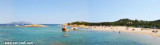
Della Bocca island is the more narrow point of the Olbia harbour access. It has a lighthouse that is prominent.
Isola della Bocca lighthouse was built in 1887 as a military building. The
lighthouse marks the entrance of Olbia harbour, the first passenger port
of Sardinia.
2012/09/30
Update
Joëlle
L'île de la Bocca est le point le plus étroit de l'accès au port d'Olbia. Elle porte un phare qui est remarquable.
Le phare est à 24m du niveau de la mer. Il indique l'entrée du port aux très nombreux navires qui quotidiennement entrent et sortent d'Olbia.
2012/09/30
Update
Joëlle
L'isola della Bocca è il più stretto punto dell'accesso al porto di Olbia ed è segnalato da uno faro
Il faro è a 24m sul livello del mare. Questo faro indica l'ingresso del porto alle numerosissime navi che quotidianamente attraccano e salpano da Olbia.
Tavolara island is a limestone massif 6 kilometres long and 500 m wide, and 565 m high.The overhanging cliffs make it inaccessible, with the exception of a bay and a beach that is located at each end of the island, Spalmatore di Fuori northeast (military zone) and Spalmatore di Terra ...
Degli Aranci gulf is is bounded, on the N, by the peninsula of which Capo Figari is the E extremity.This gulf is sheltered from NE and NW winds. Strong SE winds send in a heavy sea and storms from the N and E cause a considerable swell in the gulf. During offshore winds, which are ...
This gulf is S Cugnana gulf, S cala della Volpe. It is entered between Punta della Volpe and Punta Canigione.This gulf is the most protected area of the coast. Although the anchorage is prohibited in the Gulf because of submarine telegraph cables, many boaters anchor in this ...
Gulf of Arzachena (Arsachena), located between Punta Saline and Tre Monti Cape, is a high inlet whose banks are lined with shoals. S tip, Arzachena, W of the entrance, a beacon consists of an iron post with a sheer spherical white marks a rock particularly ...
It is the largest island of the archipelago composed of sixty islets and 7 major islands, in the NE end tip of Sardinia. It is mountainous and arid. This is the only inhabited island thoroughly. It is connected by a bridge to Caprera island where are the house and the tomb of Garibaldi. ...
This cove is located between Punta delle Saline e Punta di tronfino, S Olbia port entrance. An islet (isola Patron Fiaso) is in the center of the cove.Anchor tra the islet and the Punta delle Saline, in 6 m di sand.


")
")
")
 Della Bocca island is the more narrow point of the Olbia harbour access. It has a lighthouse that is prominent.
 L'île de la Bocca est le point le plus étroit de l'accès au port d'Olbia. Elle porte un phare qui est remarquable.
 L'isola della Bocca è il più stretto punto dell'accesso al porto di Olbia ed è segnalato da uno faro
")