Tatihou est une île protégée, trois hectares aux limites du fort y ont été établis en réserve ornithologique. On peut y voir des oiseaux nicheurs : goélands argentés, bruns et marins, tadornes de Belon?
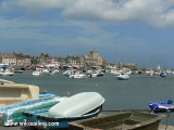
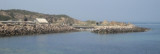
Saint-Vaast-la-Hougue is a small harbor lying 1.8 miles SW of Pointe de Saire. Ile de Tatihou, lying 1 mile E, fronts the harbor. A conspicuous tower, with a turret on one side, stands on the S extremity of the island. Fort de l’Ilet, a low fort, is situated close S of this ...
Barfleur is a small drying harbor lying 1.5 miles S of Pointe de Barfleur. It is used by fishing vessels, small coasters, and pleasure craft. Tides rise about 6.5m at springs and 5.3m at neaps. The harbor, enclosed by a jetty and a breakwater, can accommodate small vessels with ...
The islands are directly administered by the French government, and form a protected nature reserve with restricted access. Mooring is allowed between the 2 islands.
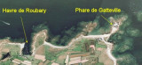
A light is shown from a square tower, 17m high, standing on Ile du Large, the NE island. Ile de Terre, lying 0.3 ...
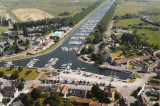
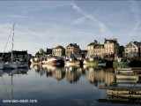
On one of the most varied coast of La Manche, Port Carentan offers "you" an execptional site. The basin, suprounded by grass and trees, blends perfectly into the town. The acces to Port Carentan, is through one of the most beautiful parts of "Parc Naturel des Marais du Cotentin". Port ...


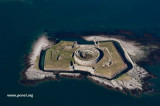
 Fort au sud de l'île.