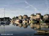
Barfleur is a small drying harbor lying 1.5 miles S of Pointe de Barfleur. It is used by fishing vessels, small coasters, and pleasure craft. Tides rise about 6.5m at springs and 5.3m at neaps. The harbor, enclosed by a jetty and a breakwater, can accommodate small vessels with ...
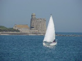
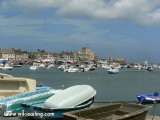
Saint-Vaast-la-Hougue is a small harbor lying 1.8 miles SW of Pointe de Saire. Ile de Tatihou, lying 1 mile E, fronts the harbor. A conspicuous tower, with a turret on one side, stands on the S extremity of the island. Fort de l’Ilet, a low fort, is situated close S of this ...
Tatihou est une île protégée, trois hectares aux limites du fort y ont été établis en réserve ornithologique. On peut y voir des oiseaux nicheurs : goélands argentés, bruns et marins, tadornes de Belon?
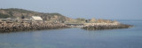
Port du Cap Levi, a small drying harbor, lies 0.5 mile S of the light. It is used by local fishing boats and yachts. An area of rocky shoals extends up to about 2 miles N of Cap Levi and is marked by a lighted buoy. This area is steep-to and the sea breaks on it in rough weather. ...


 Zone de mouillage pour des petites unités.