Giraavaru Irumathee Kandu and Giraavaru Uthuru kandu (N Kaafu)
Latitude
Longitude
DMS
---
---
DM
---
---
DD
---
---
Characteristics
Description
A good, easily discernible channel, S of Giravaru, with a least depth of 48m in its center, leads through the barrier reef.
A wider, less deep channel lies NW of Giravaru; a shoal patch, with a least depth of 3.4m, lies in the channel, about 0.7 mile NW of Giravaru, where it broadens out into the lagoon.
Funadhoo (Funidu) lies about 0.3 mile N of the E end of Male, and is surrounded by a reef which dries in places. A small tank farm, with three large and about six smaller tanks,stands on the island.
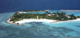
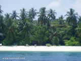
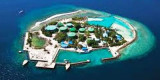
Giraavaru an islet covered in scrub and with a few coconut palms, lies on the SW side of Male Atoll, about 0.5 mile within the outer edge of the barrier reef. A small bare islet lay at the extremity of the reef extending 1 mile W of Giravaru; a similar islet lies 1 mile S of Giravaru. It's ...
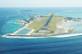
Hulule, about 0.6 mile E of Funadhoo, bears some tall coconut palms; an airstrip runs the full length of the island and joins it to an islet close S. Airport buildings and a small village lie along the central part of the W side of Hulule. The Malé International Airport is located ...
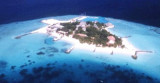
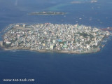
Malé is the capital of the Republic of Maldives located at the southern edge of North Male' Atoll Kaafu. Traditionally it was the King's Island from where the ancient Maldive Royal dynasties ruled and where the palace was located. Formerly it was a walled city surrounded by fortifications ...
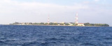
Viligili (Wilingili), a low wooded islet used as a tourist village, lies 1 mile W of Male. It is surrounded by steep-to foul ground extending up to 0.3 mile offshore. The light on the islet is reported to be a good landmark. The channel between Viligili and Male has a 5.5m shoal ...
Feydhoofinolhu, a bare sandy islet, surrounded by a steep-to reef which dries in places, lies 2.3 miles N of Viligili. Breakwaters extend from the islet.Galu Falhu, a circular reef about 1 mile SE of Feydhoofinolhu, appears to contain deep water.


 A good, easily discernible channel, S of Giravaru, with a least depth of 48m in its center, leads through the barrier reef.