Giraavaru Irumathee Kandu and Giraavaru Uthuru kandu (N Kaafu)
Latitude
Longitude
DMS
---
---
DM
---
---
DD
---
---
Caractéristiques
Description
A good, easily discernible channel, S of Giravaru, with a least depth of 48m in its center, leads through the barrier reef.
A wider, less deep channel lies NW of Giravaru; a shoal patch, with a least depth of 3.4m, lies in the channel, about 0.7 mile NW of Giravaru, where it broadens out into the lagoon.
Funadhoo (Funidu) lies about 0.3 mile N of the E end of Male, and is surrounded by a reef which dries in places. A small tank farm, with three large and about six smaller tanks,stands on the island.
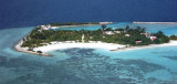
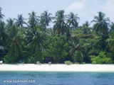
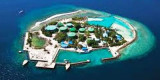
Giraavaru an islet covered in scrub and with a few coconut palms, lies on the SW side of Male Atoll, about 0.5 mile within the outer edge of the barrier reef. A small bare islet lay at the extremity of the reef extending 1 mile W of Giravaru; a similar islet lies 1 mile S of Giravaru. It's ...
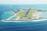
Hulule, about 0.6 mile E of Funadhoo, bears some tall coconut palms; an airstrip runs the full length of the island and joins it to an islet close S. Airport buildings and a small village lie along the central part of the W side of Hulule. The Malé International Airport is located ...
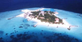
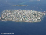
Posée sur les flots, la capitale des Maldives compte 100 000 habitants sur 2 km², soit le tiers de la population du pays. La ville est située sur l'île de Malé d'une superficie de 1,5 km² dans l'atoll de Malé (Kaafu) dans le sud de l'archipel des Maldives. Malé est depuis ...
Viligili (Wilingili), a low wooded islet used as a tourist village, lies 1 mile W of Male. It is surrounded by steep-to foul ground extending up to 0.3 mile offshore. The light on the islet is reported to be a good landmark. The channel between Viligili and Male has a 5.5m shoal ...
Feydhoofinolhu, a bare sandy islet, surrounded by a steep-to reef which dries in places, lies 2.3 miles N of Viligili. Breakwaters extend from the islet.Galu Falhu, a circular reef about 1 mile SE of Feydhoofinolhu, appears to contain deep water.


 A good, easily discernible channel, S of Giravaru, with a least depth of 48m in its center, leads through the barrier reef.