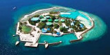

Funadhoo island (Kaafu)
1.7nm
262°
A small tank farm, with three large and about six smaller tanks,stands on the island.
17 Nov 11
Jojo
| Latitude | Longitude | |
| DMS | --- | --- |
| DM | --- | --- |
| DD | --- | --- |


")
")
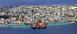
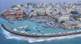
 Malé is the capital of the Republic of Maldives located at the southern edge of North Male' Atoll Kaafu.
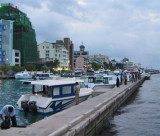
A commercial harbour is located in the Island. It is the heart of all commercial activities in the country. Many government buildings and agencies are located on the waterfront.
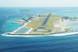
Malé International Airport is on adjacent Hulhule Island which includes a seaplane base for internal transportation.
Several land reclamation projects have expanded the harbour.
From the few observations made in the vicinity of Male, it seems likely that the water movement there is far more influenced by the monsoon currents than the tidal currents.
When the currents are flowing strongly, it seems likely that the tidal currents are only strong enough to increase or decrease the resulting flow and rarely strong enough to reverse its direction. Due to the probability of strong and unpredictable currents, an approach by night is not recommended.
In the channel E of Male, the currents from Vaadhoo Kandu (Wadu Channel) set across. During the Northeast Monsoon, a component of the current sets NW through this channel, setting a vessel towards the reef fringing the E side of Male. The flow turns W between Male and Funadoo.
It is reported that this flow commenced 1.5 hours before HW, and ran until 1.5 hours before LW, attaining a maximum velocity of 2.5 to 3 knots at about HW N of Male breakwater, where it sets strongly across the N face of the breakwater. At the same time the flow was weak and variable E of Funadhoo. Strong sets have also been reported during the Northeast Monsoon in Male Harbor.
During the Southwest Monsoon, a component of the current enters the lagoon through the channel S of Giravaru, flowing out principally through the channel W of Male and between Male and Funadhoo, and then S into Vaadhoo Kandu (Wadu Channel) .
It was reported (1972) that an E set existed until within the line joining Male and Hulule, then slack water between Funadhoo and Dunidu, when a strong E set was experienced to the anchorage. Four hours after LW, with the flood current tending to oppose the current, a moderate NE flow was experienced in the lagoon.
No observations have been made during the change in the monsoons when the currents could be weak and variable at times, but trong sets may always be encountered.
Male is identified from N and NE by a white mosque and minaret, and radio masts at its SE corner.
The E, S, and W coasts of Male are fringed by an unbroken reef, awash, extending from 23m to 0.2 mile from the S coast.
The N side of the island is protected by a breakwater, about 1.2m high and 4m wide, which is connected to the land at each end.
Six passages lead through the breakwater into the harbor, with another into a shallow pool at the W end. Lights are shown from beacons, painted in black and white bands, lying on each side of each of the passages passages.
 Posée sur les flots, la capitale des Maldives compte 100 000 habitants sur 2 km², soit le tiers de la population du pays.
La ville est située sur l'île de Malé d'une superficie de 1,5 km² dans l'atoll de Malé (Kaafu) dans le sud de l'archipel des Maldives.
Malé est depuis 800 ans le centre des Maldives. Récemment la population de l'île a tellement augmenté que l'on a dû l'agrandir artificiellement pour satisfaire à la demande croissante.
Aujourd'hui plus d'un tiers de la surface de l'île a été gagné sur l'Océan Indien. L'île est densément urbanisée, la ville prenant l'essentiel de la surface de l'île.
Une base d'hydravions ainsi qu'un port sont situés sur l'île.
L'aéroport international de Malé est situé sur l'île d'Hulule avoisinante.
De nombreux projets d'extension sur la mer ont permis d'agrandir le port.
Malé est le centre du commerce de la noix de coco, de la fibre de coco, du coprah, et des coquillages de cowry.
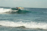
Les meilleurs spots de surf se situent dans les atolls de Malé N et de Malé S. Pour la région de Malé Nord en général, la saison du surf s'étend d'avril à octobre. Dans le S, des safaris-surf sont organisés sur l'atoll de Hadhdhunmalthee et celui de Huvadhoo.
Comme ces deux atolls sont séparés par le "1° channel" (un canal de 1° de latitude) et qu'il existe une masse terrestre très réduite au S de celui-ci, une houle générée par les quarantièmes rugissants (phénomène météorologique créé à l'extrème S de l'Océan Indien) vient frapper les îles de ces deux atolls avec une grande vigueur, créant les meilleures vagues du pays. La meilleure saison pour s'y rendre tourne autour de janvier.
Ebook | Maldives
|