Crocker Reef (Plantation Key)

Crocker Reef (Plantation Key)

To precisely geolocate this site. Update if necessary.

Localisation

Crocker Reef (Plantation Key)
LatitudeLongitude
DMS------
DM------
DD------

Characteristics

Mooring buoy
Mooring
Sand
Beacon
Diving
Wreck

Description

Crocker Reef (Plantation Key)
2010-04-01
Update
Joëlle
Crocker Reef (Plantation Key)
2010-04-01
Update
Joëlle
Crocker
Reef (Buoy 12) is located about 4 miles southeast of Snake
Creek in Islamorada.  This reef is primarily an intermediate to deep spur
& groove system typical of the outer reef along most of the Florida Keys. Not far from the navigation buoy pictured above is a mooring ball known as the Dropoff or
Deep
Ball where the site starts at 45' to 50' and slopes to about 85' before it plateaus into sand.  Nearby is the Ski Slope, a wide sandy ravine.  Further to the southwest is the Shallow Ball also known as Crocker 35 and Crocker
Orbit or Coral Fingers.  This area is similar , but starts at about 35' and slopes more gradually and for a longer distance before getting deep.  

The
Crocker Reef area is far enough out that it usually has good visibility,  blue water and lots of large fish & sponges. Current is not often a problem, and when there is a current, drift dives along Crocker
Reef are always an enjoyable experience. On most parts of Crocker Reef the grooves can be followed from northwest (shallow) to southeast (deep) making natural navigation easy.

Other areas nearby with local names are
The
Cage (where a shark cage once was), 3 Amigos (Three large mounds near coral fingers), Pillar Coral Ridge, which features a wrecked small boat, and The
Telephone - a long patch reef with a telephone-shaped sand hole. Not far to the northeast is Davy Crocker or Pleasure, located about halfway between Davis Reef & Crocker Reef.

2012/04/16
Update
JB

The buoy 16 - La bouée 16
2012/04/9
Update
Cham
Ebook

Gulf of Mexico

  • 227 sites
  • 182 photos
  • publication date: 9 Jul 2023
  • .pdf file size: 78 Mb
Crocker Reef (bouée 12) est situé à environ 4 miles au SE de Snake Creek à Islamorada. Cet écueil est d'abord un intermédiaire pour stimuler le système de rainures profondes et typique du récif extérieur le long de la plupart des Florida Keys. Non loin de la bouée de navigation se trouve une boule de mouillage connue sous le nom
Dropoff ou Deep Ball où le site commence de 13,5 m à 15 m et des pentes à environ 25,5 m avant les plateaux dans le sable. A proximité telle une piste de ski, se trouve un ravin de sable. De plus au SW se trouve la boule Shallow également connu comme Crocker 35 et Crocker Orbit ou corail Fingers. Cette région est similaire, mais commence à environ 10,5 m et les pentes descendent plus progressivement et sur une distance plus longue avant d'obtenir de la  profondeur.
La zone Crocker Reef est suffisamment loin pour avoir généralement une bonne visibilité, l'eau bleue et beaucoup de gros poissons et d'éponges. Le courant n'est pas souvent un problème, et quand il y a du courant, on peut pratiquer la plongée en dérive le long du récif Crocker, c'est toujours une expérience agréable. Sur la plupart des régions du Crocker Reef les rainures peuvent être suivies du nord-ouest (peu profond) au sud-est (profond), cela rend la navigation facile.
D'autres domaines à proximité avec des noms locaux sont La Cage (où était autrefois une cage de requin ), 3 Amigos (3 grandes buttes de corail en forme de doigts), le pilier Coral Ridge, où un petit bateau fit naufrage, et le téléphone - un long récif de sable en forme de téléphone. Non loin vers le NE se trouve
Davy Crocker ou d'agrément, situé à environ mi-chemin entre Davis Reef
& Crocker Reef.
2012/04/16
Update
JB
Share your comments or photos on "Crocker Reef (Plantation Key)"

Sites around Crocker Reef (Plantation Key)

Flying distances - Direct line

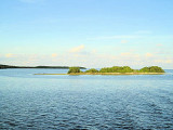
Long Key (ou Rattlesnake key) (Florida Keys)

15nm
253°
Long Key was called Cayo Vivora (Rattlesnake Key) by early Spanish explorers, a reference to the shape of the island, which resembles a snake with its jaws open, rather than to its denizens.
In the early 20th century, Long
Key was the site of a luxurious fishing resort that ...
5 Apr 10
Joëlle

Lower Matecumbe Key (Florida Keys)

11nm
256°
The island lies to the southwest of Upper Matecumbe Key, and to the northeast of Craig
Key.
All of the key is within the Village of Islamorada as of November 4, 1997, when it was incorporated.
This key is the site of a number of Indian mounds and middens, most of which were ...
22 Mar 10
Joëlle

John Pennekamp Coral Reef State Park (Key Largo)

16nm
33°
The first underwater park in the U.S., John Pennekamp Coral Reef State
Park encompasses approximately 70 nautical square miles.
It is the coral reefs and their associated marine life that bring most visitors to the park.
Many enjoy the view of the reef from a glass-bottom ...
31 Mar 10
Joëlle

Treasure Harbor marina (Plantation Key)

4.1nm
311°
Marina is located at the W end of Plantation Key, just before Islamorada village.
Plantation Yacht Harbor lies off the Florida Straits. Between
ICW markers 78 and 78A. It will bear approximately 150°.
Look for red and white lighthouse at the end of the breakwater.
Reservations ...
27 Mar 10
Alain

Mangrove Marina (Key Largo)

6nm
357°
Mangrove Marina is located on Key Largo, at ICW marker #65 and between day markers #1 and #2.130 slips with 15 transients (<65 feet)
Reservations are preferred.
Tel - (305) 852-8380
Fax - (305) 852-9466
Email - mangrove@terranova.net
27 Mar 10
Alain

Tavernier Creek Marina (Plantation Key)

5.6nm
352°
Whether you are fishing, cruising, or diving, we are most conveniently located on Tavernier Creek, with easy access to the Atlantic Ocean and
Florida Bay.On the Bayside, Flashing Green # 71 On the Oceanside, Black & White flashing buoy.Tel: 305-852-5854
Fax:305-852-7425
Email: ...
27 Mar 10
JB