Coromandel coast (E India)

Coromandel coast (E India)

To precisely geolocate this site. Update if necessary.

Localisation

Coromandel coast (E India)
LatitudeLongitude
DMS------
DM------
DD------

Characteristics

Coast

Description

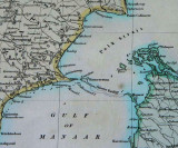
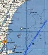
The Coromandel Coast is the name given to the southeastern coast of the Indian Subcontinent between Cape Comorin and False Divi Point.
It may also include the southeastern coast of the island of Sri Lanka.

The coast is generally low, and punctuated by the deltas of several large rivers, including the Kaveri (Cauvery), Palar, Penner, and Krishna, which rise in the highlands of the Western Ghats and flow across the Deccan Plateau to drain into the Bay of Bengal.
The alluvial plains created by these rivers are fertile and favour agriculture. The coast is also known for its ports and harbours, Pulicat, Chennai (Madras), Sadras, Pondicherry, Karaikal, Cuddalore, Tranquebar, Nagore, and Nagapattinam, which take advantage of their close proximity with regions rich in natural and mineral resources (like the Chhattisgarh belt and the mines of Golconda and Kolar) and/or good transport infrastructure.The Coromandel Coast falls in the rain shadow of the Western Ghats, and receives a good deal less rainfall during the summer southwest monsoon, which contributes heavily to rainfall in the rest of India. The region averages 800 mm/year, most of which falls between October and December. The topography of the Bay of Bengal, and the staggered weather pattern prevalent during the season favours northeast monsoon, which has a tendency to cause cyclones and hurricanes rather than a steady precipitation. As a result, the coast is hit by inclement weather almost every year between October to January. The high variability of rainfall patterns are also responsible for water scarcity and famine in most areas not served by the great rivers. For example, the city of Chennai is one of the driest cities in the country in terms of potable water availability, despite high percentage of moisture in the air, due to the unpredictable, seasonal nature of the monsoon.The Coromandel Coast is home to the East Deccan dry evergreen forests ecoregion, which runs in a narrow strip along the coast. The Coromandel coast is also home to extensive mangrove forests along the low-lying coast and river deltas, and several important wetlands, notably Kaliveli Lake and Pulicat Lake, that provide habitat to thousands of migrating and resident birds.
2012/03/23
Update
Jojo
Coromandel coast (E India)
2012-03-23
Update
Jojo
thelangana
2017/07/24
Update
Northern circar coast

2018/09/24
Update
9515571773
india
2019/08/28
Update
Ebook

Bay of Bengal

  • 110 sites
  • 82 photos
  • publication date: 7 Jul 2023
  • .pdf file size: 53 Mb
Share your comments or photos on "Coromandel coast (E India)"

Sites around Coromandel coast (E India)

Flying distances - Direct line

Gulf of Mannar (SE India)

206nm
187°
The Gulf of Mannar lies between the SE coast of the Indian Peninsula and the W coast of Sri Lanka. Its S boundary lies between Cape Comorin, the S extremity of India, and Point de Galle, the SW point of Sri Lanka. The gulf is bounded N by Adam’s Bridge, a chain of islets and rocks ...
20 Mar 12
Jojo

Palk Strait North side (E India)

101nm
167°
The N shore of Palk Strait consists of the low-lying coast between Point Calimere and a low point, about 39 miles WSW, which projects from the coast close S of the entrance to the Vellar River.
Between Point Calimere and Atirampattinam, about 29 miles W, the coast consists of mud ...
23 Mar 12
Jojo

Nizampatam Bay (Andhra Pradesh-E India)

240nm
17°
Nizampatam Bay lies between Kottapatam and False Divi Point, about 41 miles ENE, and recedes about 14 miles to the N. Except for the shoals in the vicinity of Mutapolli Bank, the bay is free from dangers and its shores may be approached with safety to a depth of 9.1m.A backwater is ...
28 Mar 12
Jojo

Pondicherry port (E India)

35nm
83°
Pondicherry (Pondicherri), the capital and seat of government of the Union Territory of Pondicherry, lies about 13 miles N of Cuddalore. All cargo is handled by lighters at the anchorage off the town.Puducherry currently has a small shallow water port used for the import & export ...
25 Mar 12
Jojo

Cuddalore port (Tamil Nadu-E India)

32nm
104°
Cuddalore is a fast growing industrial city and headquarter of Cuddalore district in the Tamil Nadu state of southern India. Located 25 kilometres south of Pondicherry on the coast of Bay of Bengal, Cuddalore has a large number of industries which employ a great deal of the city's ...
25 Mar 12
Jojo

Pondicherry lighthouse (E India)

35nm
82°
Pondicherry Light, with a racon, is shown from a white tower with black bands. A ruined iron pier projects E about 0.2 mile from the shore, 1 mile NNE of the light.
The following landmarks are conspicuous from the offing:1. A red chimney, 56m high, about 1 mile WNW of the light.
2. ...
25 Mar 12
Jojo