The N shore of Palk Strait consists of the low-lying coast between Point Calimere and a low point, about 39 miles WSW, which projects from the coast close S of the entrance to the Vellar River.
Between Point Calimere and Atirampattinam, about 29 miles W, the coast consists of mud flats, covered with mangrove bushes, and flooded during heavy rains and high spring tides.
2012/03/23
Update
Jojo
the narrow line between India and Srilanka is known as Palk Strait
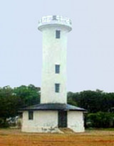
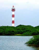
Point Calimere is the southernmost extremity of the Coromandel Coast and the NW entrance point of Palk Strait. The following conspicuous objects lie in the vicinity of the point: 1. Point Calimere Light, that is shown from a concrete tower, 18.2m high, close within the point; ...
Kachchaitivu (Kachchtivu), about 10 miles SW of Delft Island , is 12m high and overed with scrub. There is a well and a small shrine on the NE side of the island.Depths of less than 9.1m extend 1 mile SE of the island. Depths of less than 5.5m extend about 2.5 mile NE from the ...
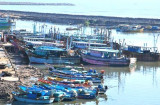
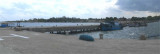
Nagapattinam (Negapatam), the principal port of the Thanjavur District, lies at the mouth of the Uppanar River.Vessels anchor in the roadstead off the port to work cargo.All cargo is handled at the anchorage by lighters. About 114 ofthese lighters are available, each with a capacity ...
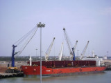
Karaikal Port is a coastal lagoon type harbor located about about 200 miles S of Chennai (Madras) and about 9 miles S of the inland city of Karaikal. The port is privately operated by Karaikal Port Private Limited (KPPL) and is located between the Pravadayanar River and the Vettar ...
Tondi, is a small port for local coasting craft. Two white masonry beacons, 4.5m high, mark the port limits. A light stands about 4.5 miles NE of Tondi.Anchorage may obtained, in 6m, mud, about 5 miles ESE of Tondi, but this position is exposed to all but offshore winds. Small ...


 The N shore of Palk Strait consists of the low-lying coast between Point Calimere and a low point, about 39 miles WSW, which projects from the coast close S of the entrance to the Vellar River.
")