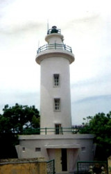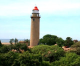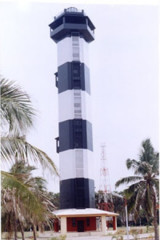

Pondicherry lighthouse (E India)
0.5nm
0°
The following landmarks are conspicuous from the offing:1. A red chimney, 56m high, about 1 mile WNW of the light.
2. ...
25 Mar 12
Jojo
| Latitude | Longitude | |
| DMS | --- | --- |
| DM | --- | --- |
| DD | --- | --- |

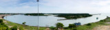
 Pondicherry (Pondicherri), the capital and seat of government of the Union Territory of Pondicherry, lies about 13 miles N of Cuddalore. All cargo is handled by lighters at the anchorage off the town.
Puducherry currently has a small shallow water port used for the import & export of general cargo. Ships anchor offshore and cargo is transferred to a small shallow draft quay by means of barges.
During the Northeast Monsoon, which usually prevails from October through January, rough seas are raised, hampering cargo operations. During the rest of the year the prevailing wind is from the W in the morning; a choppy sea is raised by the SE wind in the afternoon.
Depths surrounding the port range from the 20m curve, which lies about 2.5 miles E of the port, to about the 5m curve, which lies about 0.3 mile from the shore.
The low sandy shore S of the town is marked by trees. The land, from 3 to 5 miles NW and N of the town, is 45 to 73m high and helps to identify the locality.
The Government of India has developed a National Maritime Development
programme with a vision to make India a leading player by the year 2025.
Pilotage is not available.
Local quarantine and port regulations are in force in Pondicherry. A copy of these regulations can be obtained from the local port authorities.
A signal station lies at the inner end of the new pier at the S end of the town. Vessels can communicate with the station by using the International Code of Signals by day and Morse code at night.
The port can be contacted, as follows:
VHF channels 12 and 16
Tel: 91-413-2337114
Mail: port@pon.nic.in
During good weather, anchorage can be taken, in depths of 9.1 to 11m, about 0.8 mile off the coast at Pondicherry. From October to December, when bad weather may be expected, it is advisable to anchor about 1 mile farther offshore, using a good scope of chain. The holding ground is not very good.
Anchorage can also be taken, in depths of 9.1 to 11m, about 0.5 mile E of the head of the new pier. At this anchorage the powerhouse chimney and Rodiar Chimney are in line, bearing 276.5°.
Puducherry,(formerly known as Pondicherry), ranked as India's best small state,fast emerging as an industrial and technology destination, is an ideallocation for developing a Deep water Port. Upon completion of the development, the port will handle containers, cars, general cargo, edible oil and passenger.
Salient Features:
Design ship size: Container vessels (7000 TEU) with a draft of 14.2 mts and length of 300 mts
Dredge channel: Length - 2.5 Kms | Depth - 16.4 mts | Width - 210 mts Volume of capital dredging - 16.3 million cubic meters Dredged material will be used for land reclamation and beach formation.
Breakwaters: Northern & southern breakwaters totaling 3 Kms in length, oriented to avoid wave penetration and sediment intake & designed for 100 year return period storm.
Liquid cargo terminal: Ships pumps will be used for unloading.
Port infrastructure equipment: 2 Tugs, pilot and survey boats, navigation buoys and lights, port VTS system.
Buildings: Port
administration building, accommodation block & gate house plus
individual administration blocks and offices in each terminal.
Container terminal equipment:
10 quay side post panamax ship to shore container cranes.
3 quay side feeder ship to shore container cranes.
52 rubber tyred gantries 1 over 5.
78 tractor trailer units.
11 empty container handlers.
2 rail mounted gantries.
Quay level: +4.5 m CD
Depth at quay: -15.5 m CD
Land reclamation: Raising and filling of sea 1200m long and 200m to sea from present shoreline and area on south and north in the basin & treatment of soft marine clays.
Modal split of traffic: Trans-shipment 20%, Rail 10%, Road 70% for containers.General cargo terminal equipment Ships’ gear will be utilized.
Utilities: Government is committed to provide adequate power and water. State-of-the-art waste water and solid waste disposal facilities will be provided.
") Port Development:
The Port facilities will be commissioned by 2012. The following will be the port facilities upon completion of development by 2017.
Container terminal - 1670 m long with annual throughput capacity of 2.25 million TEU
General cargo / ro-ro berth - 300 m long with annual throughput capacity of 180000 cars
Edible oil berth - One liquid cargo terminal handling 200,000 tonnes per annum
Cruise terminal - 300 m long with annual throughput capacity of 23350 passengers
Sand bypassing and beach nourishment - Bypass the sand from south of the port to the beach of Puducherry
Port Development:
The Port facilities will be commissioned by 2012. The following will be the port facilities upon completion of development by 2017.
Container terminal - 1670 m long with annual throughput capacity of 2.25 million TEU
General cargo / ro-ro berth - 300 m long with annual throughput capacity of 180000 cars
Edible oil berth - One liquid cargo terminal handling 200,000 tonnes per annum
Cruise terminal - 300 m long with annual throughput capacity of 23350 passengers
Sand bypassing and beach nourishment - Bypass the sand from south of the port to the beach of PuducherryEbook | Bay of Bengal
|