
Golfo di Orosei (Sardegna)
1.5nm
147°
9 Oct 12
Joëlle
| Latitude | Longitude | |
| DMS | --- | --- |
| DM | --- | --- |
| DD | --- | --- |

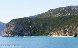
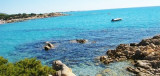
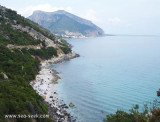
 In front of Capo Comino is a rock clearly visible from the north or south. The coastline is dotted with shoals that some places extend more than half a mile offshore: they are dangerous for coastal navigation.
Orosei gulf opens after Punta Nera. The coast is rocky and the bottom is sandy. There are several coves where you can stay. Marinas and harbors offer shelter if necessary.
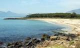
S Monte Santu cape, the coast continues to be high, rocky and inaccessible for 6 NM. It then becomes low and sandy far as Bellavista Cape.
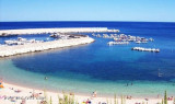
Bellavista cape houses on the N side, the harbor and the town of Arbatax: they are low and indented, appearing as an island, as seen from N or S, but with a different look.
")
 En face de Capo Comino se trouve un rocher bien visible depuis le nord ou le sud. Le littoral est parsemé de bas-fonds qui certains endroits, s'étendent à plus d'un demi-mile au large: ils sont dangereux pour la navigation côtière.
Le golfe d'Orosei s'ouvre après la Punta Nera. La côte est rocheuse et le fond sablonneux. Les criques où vous pouvez séjourner sont nombreuses. Les Marinas et les ports offrent un abri en cas de besoin.
Au S du cap Monte Santu, la côte continue d'être élevée, rocheuse et inaccessible pendant 6 MN. Elle devient ensuite basse et sablonneuse jusqu'au cap Bellavista.
Le cap Bellavista abrite, sur le côté N, le port et la ville d'Arbatax: ceux-ci sont bas et découpés, apparaissant comme une île, vus du N comme du S, mais avec un aspect différent.
 Di fronte a Capo Comino si nota uno scoglio ben visibile sia da Nord che
da Sud. La costa è cosparsa di secche e scogli che in alcuni punti si
protendono al largo per oltre mezzo miglio: sono pericolosi per la
navigazione costiera.
Di fronte a Capo Comino si nota uno scoglio ben visibile sia da Nord che
da Sud. La costa è cosparsa di secche e scogli che in alcuni punti si
protendono al largo per oltre mezzo miglio: sono pericolosi per la
navigazione costiera.L'isola Ruja da un buon ridosso dallo scirocco.
Il golfo di Orosei si apre dopo la Punta Nera. La costa è rocciosa e il fondo sabbioso. Le cale dove si puo sostare sono numerose. Marina e porti offrono ripari in caso di necessità.
S capo Monte Santu, la costa continua ad essere alta, rocciosa e inaccessibile per 6 MN. Diventa allora bassa e sabbiosa fino a Capo Bellavista.
Il Capo Bellavista presenta, nel versante N, il porto e la cittadina di Arbatax: esso si presenta basso e frastagliato sul mare, apparendo come un'isola, sia visto da nord che da S, anche se con diverse sembianze.
Ebook | Sardegna East
|
Ebook | Sardegna
|