Cape Sable (Florida)

Cape Sable (Florida)

To precisely geolocate this site. Update if necessary.

Localisation

Cape Sable (Florida)
LatitudeLongitude
DMS------
DM------
DD------

Characteristics

Sea pee
Mooring
Sand
Ice
Beach
Sand

Description

Cape Sable (Florida)
2010-02-23
Update
Joëlle
Cape Sable (Florida)
2010-02-23
Update
Joëlle
Cape Sable (Florida)
2010-02-23
Update
Joëlle
Ebook

Gulf of Mexico

  • 227 sites
  • 182 photos
  • publication date: 9 Jul 2023
  • .pdf file size: 78 Mb
Enchorage is possible only when the weather is fair, near N or S of Middle Cape.
Minimum depht: 7 feet.
East Cape
2010/03/21
Update
bjvlb
Cape Sable, is the southernmost point of the US mainland Florida. It is located in southwestern Florida, in Monroe County, and is part of the Everglades National Park. The cape is a peninsula issuing from the southeastern part of the Florida mainland, running west and curving around to the north, reaching Ponce de Leon Bay, at the mouth of the Shark River. It forms the southern and western margins of Whitewater Bay.
There are three prominent points on the cape: East Cape, Middle Cape, also known as Palm Point, and Northwest Cape.
2010/03/21
Update
bjvlb
North cape.
2010/03/21
Update
bjvlb
I love minecraft!


2013/03/11
Update
Cape Sable est le point le plus méridional de la Floride continentale et des États-Unis continentaux.
Il est situé au SW de la Floride, dans le comté de Monroe et fait partie du parc national des Everglades.

Le cap est une péninsule allant du SE de la Floride continentale en direction de l'W et s'incurvant vers le N alors qu'elle atteint la Ponce de Leon Bay, à l'embouchure de la Shark River. Il borde au S et à l'W la Whitewater Bay.

Il a trois points connus : East Cape, Middle Cape, connu également sous le nom de Palm Point, et Northwest Cape.

Middle Cape:
2010/03/21
Update
bjvlb
On peut mouiller, par beau temps, au N ou au S de Middle Cape par environ 2 m.
2010/03/21
Update
bjvlb
Share your comments or photos on "Cape Sable (Florida)"

Sites around Cape Sable (Florida)

Flying distances - Direct line

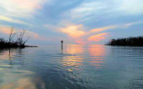
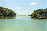
Key Vaca (Florida Keys)

26nm
172°
Key Vaca is an island in the middle Florida
Keys, located entirely within the borders of the city of Marathon, Florida. It is often incorrectly identified as
"Marathon Key."Key Vaca is located between Fat
Deer Key and Knight's Key. Key Vaca is also connected via bridge to ...
22 Mar 10
Joëlle

Long Key (ou Rattlesnake key) (Florida Keys)

26nm
134°
Long Key was called Cayo Vivora (Rattlesnake Key) by early Spanish explorers, a reference to the shape of the island, which resembles a snake with its jaws open, rather than to its denizens.
In the early 20th century, Long
Key was the site of a luxurious fishing resort that ...
5 Apr 10
Joëlle

Boot Key Harbor (Florida)

10nm
356°
Boot Key Harbor is located  into the everglades, in Florida SW, outside Little Shark River.
The entry is northwest of unlighted daybeacon #4 .
Generally it's a good mooring, with minimum 5,5 feet, when the bay is calm.
Do not swim in the bay because of Alligators. Many ...
7 Apr 12
India

Flamingo Marina (Florida)

11nm
91°
A marina on the W side of the canal just below the dam at Flamingo has berths with electricity, water, ice, and limited marine supplies.
Gasoline, diesel fuel, and launching ramps are available on either side of the dam. A 5-mph no-wake speed limit is enforced in the canal.The ...
4 Apr 10
Alain

Flamingo canal (Florida)

11nm
91°
Flamingo, on the mainland about 9 miles E of East Cape (25°06.9'N., 81°05.2'W.), is a tourist center in
Everglades National Park at the entrance of Buttonwood (Flamingo) Canal. A 300-foot tower and an 86-foot standpipe E of the canal about 0.3 mile NE of the visitors center are ...
16 Apr 12
JB

Ponce de Leon Bay (Florida)

12nm
Ponce de Leon Bay is a nearly rectangular bight 7 miles N of Northwest Cape.
The N part of the bight is shallow, but fair anchorage is available for vessels drawing up to 6 feet off Shark River Island.
The anchorage is sheltered from winds E of N or S, and the shoal on the NW ...
7 Apr 12
India