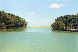
A marina on the W side of the canal just below the dam at Flamingo has berths with electricity, water, ice, and limited marine supplies. Gasoline, diesel fuel, and launching ramps are available on either side of the dam. A 5-mph no-wake speed limit is enforced in the canal.
The entrance canal, and even the marina itself, is VERY shallow. They are considering closing it off to boats over 20' because of damage to sea grass on the approach (but still open to large boats). Many boats over 20' have to enter and exit with the high tide, so be sure to check the tide tables for flamingo. Even then, once you're in a slip, your bottom might be gently resting in mud much of the time. When in doubt discuss it with the dockmaster at Flamingo. Call on VHF Ch 16. At low tide the entrance channel have depth down to 2.8 ft.
2010/04/4
Update
Alain
2010-04-04
Update
Joëlle
2010-04-04
Update
Joëlle
2010-04-04
Update
Joëlle
Un port de plaisance se trouve sur le canal du côté W, juste en dessous du barrage de Flamingo avec électricité, eau, glace, et des fournitures marines limitées. Essence, carburant diesel, et les rampes de lancement sont disponibles sur chaque côté du barrage. Une limite de 5-mi / h est appliquée dans le canal.
Le canal d'entrée, et même le port de plaisance lui-même, est très peu profond. Il est fermé au large pour les bateaux de plus de 6 m à cause des dommages occasionnés à l'herbe de mer sur l'approche (mais toujours ouvert à de grands bateaux). De nombreux bateaux de plus de 6 m à entrent et sortent à marée haute, donc n'oubliez pas de vérifier les tables de marées pour Flamingo. Même alors, une fois que vous êtes dans un slip, votre fond pourrait se reposer doucement dans la boue. En cas de doute en discuter avec le Dockmaster du Flamingo. Appel sur la VHF 16. À marée basse, le chenal d'entrée a une profondeur de 2,8 m.
Long Key was called Cayo Vivora (Rattlesnake Key) by early Spanish explorers, a reference to the shape of the island, which resembles a snake with its jaws open, rather than to its denizens. In the early 20th century, Long Key was the site of a luxurious fishing resort that ...
Key Vaca is an island in the middle Florida Keys, located entirely within the borders of the city of Marathon, Florida. It is often incorrectly identified as "Marathon Key."Key Vaca is located between Fat Deer Key and Knight's Key. Key Vaca is also connected via bridge to ...
Flamingo, on the mainland about 9 miles E of East Cape (25°06.9'N., 81°05.2'W.), is a tourist center in Everglades National Park at the entrance of Buttonwood (Flamingo) Canal. A 300-foot tower and an 86-foot standpipe E of the canal about 0.3 mile NE of the visitors center are ...
The island lies to the southwest of Upper Matecumbe Key, and to the northeast of Craig Key. All of the key is within the Village of Islamorada as of November 4, 1997, when it was incorporated. This key is the site of a number of Indian mounds and middens, most of which were ...
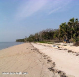
Cape Sable, is the southernmost point of the US mainland Florida. It is located in southwestern Florida, in Monroe County, and is part of the Everglades National Park. The cape is a peninsula issuing from the southeastern part of the Florida mainland, running west and curving around ...
Grassy Key is an island in the middle Florida Keys, between Crawl Key and Duck Key. It is one of the northernmost islands in a chain of islands that comprise the City of Marathon, Florida.


 canal 16


 A marina on the W side of the canal just below the dam at Flamingo has berths with electricity, water, ice, and limited marine supplies.
")
")
")
 Un port de plaisance se trouve sur le canal du côté W, juste en dessous du barrage de Flamingo avec électricité, eau, glace, et des fournitures marines limitées. Essence, carburant diesel, et les rampes de lancement sont disponibles sur chaque côté du barrage. Une limite de 5-mi / h est appliquée dans le canal.