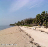

Boot Key Harbor (Florida)
2.1nm
202°
The entry is northwest of unlighted daybeacon #4 .
Generally it's a good mooring, with minimum 5,5 feet, when the bay is calm.
Do not swim in the bay because of Alligators. Many ...
7 Apr 12
India
| Latitude | Longitude | |
| DMS | --- | --- |
| DM | --- | --- |
| DD | --- | --- |


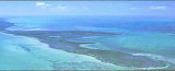
 Ponce de Leon Bay is a nearly rectangular bight 7 miles N of Northwest Cape.
The area for some 10 miles E and SE of Ponce de Leon Bay is a complicated network of tidal channels around thousands of mangrove islands. These channels lead or enlarge into Oyster, Whitewater, and Tarpon
Bays, from which, in turn, shallow rivers lead back into The Everglades.
Generally, a depth of 5 feet can be carried through the various passes into Oyster and Tarpon Bays by giving a good berth to the points, which often have tidal bars projecting out from them.
Ebook | Gulf of Mexico
|
 Ponce de Leon Bay est une baie rectangulaire, située sur le golfe du Mexique au sud-ouest de la Floride à 81 degrés de longitude et de 10,6 de latitude.
 Ponce de Leon mène dans la baie Oyster Bay à l'est, puis dans la baie de Whitewater. La baie est située entre le Cap Nord-Ouest et Shark Point. Elle porte le nom de Juan Ponce de León, un explorateur européen qui fut le premier Européen à atteindre la Floride.
Dans cette baies se trouvent 10 000 petites îles et îlots entrelacés de petites rivières et d'importants marécages à l'intérieur. Les îles et îlots sont généralement des morceaux de boue, bas avec des forêts denses. Il est pratiquement impossible de les identifier pour un étranger. Petits en taille, ils sont pour la plupart à fleur d'eau à marrée haute et bordés de récifs à huitres.
A l'exception des feux indiquant la frontière maritime du Parc National des Everglades, les seuls autres points remarquables sont le feu à l'entrée de la rivière Little Shark et les erbres un epu plus hauts qui forment les forêts de Shark River Island , Shark point, et Highland Point.
L'eau est peu profonde à 10 M de la côte, la profondeur est de 2,1 m à 3 M au large.
La partie N de la baie est peu profonde, mais elle offre un mouillage agréable pour les bateaux ayant un TE de 1,8 m.
Le mouillage est à l'abri des vents de N, E et S et le haut-fond offre une bonne protection du NW.