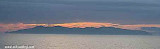
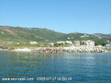
Cap Grosso et sémaphore du cap Corse avec au loin l'Ile de La Giraglia. 2005-07-18 Bearing:90°
2007-07-11
Update
Mobile
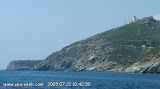
Cap Grosso et sémaphore du cap Corse. 2005-07-18 Bearing:240°
2007-07-11
Update
Mobile
La cala di Arinella or Arinetta is located E from the signal station of Cape Grosso. During good weather it is a beautiful place and there is never anyone!
Yuo can anchor in front of shingle beach, there is enough water.
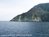
Grosso cape, 127m high, is located 1.2 miles NE of Capo Bianco and surmounted by a signal station.
The prominent villages of Tollare and Barcaggio are situated 1.2 miles and 1.8 miles E, respectively, of the cape. A prominent round tower stands near the village of Tollare.
2012/04/30
Update
Jojo
L'Anse de l'Arinella ou Arinetta est située à l'Est du sémaphore du Cap Grosso. Par beau temps c'est un endroit sublime et il n'y a jamais personne!
Vous pouvez jeter votre ancre devant la plage-éboulis, il y a suffisamment d'eau.
Le Cap Grosso est l'endroit le plus sauvage du Cap corse. Le sémaphore du Cap Corse est bâti sur le côté Ouest, à 127 mètres d'altitude. Il est doublé au-dessus, en alignement N-S, par une tour génoise, perchée à 364 mètres d'altitude.
Capo Sagro is located at 11 NM. S Finocchiarola islands. He has a signal station and a semaphore rises N of it. Mount Merizatodio, 778 m high, is 1.5 MN to W Cape and dominates the immediate area.
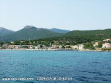
The village of Erbalunga, situated 1.5 miles SSW of Capo Sagro, stands on the S ...
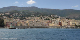
Capraia is one of the seven islands of the Tuscan Archipelago, on the road between Cape Corsica and Elba. It is an island of 335 inhabitants (the Capraiesi) of the Province of Livorno. It lies 64 km from Livorno, 37 km from Gorgona and 31 km from Corsica. Its area is 19 km2. It has ...
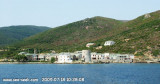
The marina of Tollare is located in the district of Ersa (135 inhabitants), in the extreme N of Cape Corse.Tollare, at the mouth of Granaghjulu river, extends its old houses around the chapel of St. Anne and its Genoese tower built round slate.
Capo Bianco, the NW extremity of the peninsula of Cap Corse, has a whitish appearance, but the coast to the N of it is rugged and black. We can anchor between cape Bianco and Centuri. Sheltered from E wind, but open at from the offshore.
Barcaggio is a large bay without protection and without depth. Opposite, at north, rises the island of Giraglia. Winds often change direction here. The breeze from east-southeast stops there and that of W-SW returns there. Barcaggio is a peaceful little port at the bottom of a bay.


 Cap Grosso et sémaphore du cap Corse avec au loin l'Ile de La Giraglia.
 Cap Grosso et sémaphore du cap Corse.
 La cala di Arinella or Arinetta is located E from the signal station of Cape Grosso.
 L'Anse de l'Arinella ou Arinetta est située à l'Est du sémaphore du Cap Grosso.