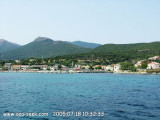
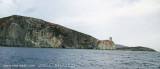
The marina of Tollare is located in the district of Ersa (135 inhabitants), in the extreme N of Cape Corse.
Tollare, at the mouth of Granaghjulu river, extends its old houses around the chapel of St. Anne and its Genoese tower built round slate.
Do not exceed the tower raised since then due west to the rock outcrops are numerous. You can anchor off the beach in low TE or N of the tower by 10 meters deep.
2012/05/4
Update
Jojo
La marine de Tollare, est située sur la commune d'Ersa (135 habitants), à l'extrême nord du Cap Corse.
Tollare, à l'embouchure du ruisseau Granaghjulu, étend ses maisons anciennes autour de sa chapelle Saint-Anne et de sa tour génoise ronde bâtie en schiste.
Il ne faut pas dépasser la tour relevée plein Ouest car ensuite les têtes de rochers sont nombreuses. On peut mouiller devant la plage par faible TE ou au N de la tour par 10 m de fond.
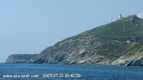
Capo Sagro is located at 11 NM. S Finocchiarola islands. He has a signal station and a semaphore rises N of it. Mount Merizatodio, 778 m high, is 1.5 MN to W Cape and dominates the immediate area.
The village of Erbalunga, situated 1.5 miles SSW of Capo Sagro, stands on the S ...
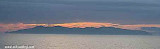
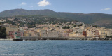
Capraia is one of the seven islands of the Tuscan Archipelago, on the road between Cape Corsica and Elba. It is an island of 335 inhabitants (the Capraiesi) of the Province of Livorno. It lies 64 km from Livorno, 37 km from Gorgona and 31 km from Corsica. Its area is 19 km2. It has ...
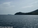
Barcaggio is a large bay without protection and without depth. Opposite, at north, rises the island of Giraglia. Winds often change direction here. The breeze from east-southeast stops there and that of W-SW returns there. Barcaggio is a peaceful little port at the bottom of a bay.
La cala di Arinella or Arinetta is located E from the signal station of Cape Grosso. During good weather it is a beautiful place and there is never anyone!Yuo can anchor in front of shingle beach, there is enough water. Grosso cape, 127m high, is located 1.2 miles NE of Capo ...
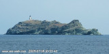
Giraglia island lies N of the peninsula of Cap Corse, 1 mile NNW of Punta d’Angelo. This small island lies at the N end of the coastal bank and is steep and surmounted by an old square tower. A light is shown from a prominent tower, 26m high, standing on the N part of the island.It ...
Near Barcaggio, on the distict of Rogliano, is located the the genoese tower of "Agnellu", built on the promontory of Agnello cape, at the NE end of the Cap Corse peninsula. With Giraglia island, the tip of Agnello marks the N end of the Corsica.S of Agnello point, it is possible ...


 The marina of Tollare is located in the district of Ersa (135 inhabitants), in the extreme N of Cape Corse.
 La marine de Tollare, est située sur la commune d'Ersa (135 habitants), à l'extrême nord du Cap Corse.