Tavolara island is a limestone massif 6 kilometres long and 500 m wide, and 565 m high.The overhanging cliffs make it inaccessible, with the exception of a bay and a beach that is located at each end of the island, Spalmatore di Fuori northeast (military zone) and Spalmatore di Terra ...
Degli Aranci gulf is is bounded, on the N, by the peninsula of which Capo Figari is the E extremity.This gulf is sheltered from NE and NW winds. Strong SE winds send in a heavy sea and storms from the N and E cause a considerable swell in the gulf. During offshore winds, which are ...
This gulf is S Cugnana gulf, S cala della Volpe. It is entered between Punta della Volpe and Punta Canigione.This gulf is the most protected area of the coast. Although the anchorage is prohibited in the Gulf because of submarine telegraph cables, many boaters anchor in this ...
Gulf of Arzachena (Arsachena), located between Punta Saline and Tre Monti Cape, is a high inlet whose banks are lined with shoals. S tip, Arzachena, W of the entrance, a beacon consists of an iron post with a sheer spherical white marks a rock particularly ...
It is the largest island of the archipelago composed of sixty islets and 7 major islands, in the NE end tip of Sardinia. It is mountainous and arid. This is the only inhabited island thoroughly. It is connected by a bridge to Caprera island where are the house and the tomb of Garibaldi. ...
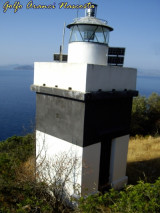
Figarolo island is located SW Figari cape, after Punta Filasca, facing cala Moresca, in the Aranci gulf. That island, pyramidal in shape, is 141 m high.It is marked by a light.We can access to a small beach of the same name that is NW of the island.A narrow passage, with a depth ...


 6 Ã 10 m


 Anchoragio, by 6 to 10 m, S Figari cape, behind Figarolo island, N Aranci gulf.
 Mouillage, par 6 à 10 m, au sud du cap Figari derrière l'ilot Figarolo, au nord du golfe d'Aranci.
 Ancoraggio, da 6 a 10 m, S capo Figari, dietro l'isola Figarolo, al N dello golfo degli Aranci.
")
") Cala Moresca, anse E
Cala Moresca, anse E") Cala Moresca, anse W
Cala Moresca, anse W