Gulf of Arzachena (Arsachena), located between Punta Saline and Tre Monti Cape, is a high inlet whose banks are lined with shoals. S tip, Arzachena, W of the entrance, a beacon consists of an iron post with a sheer spherical white marks a rock particularly ...
It is the largest island of the archipelago composed of sixty islets and 7 major islands, in the NE end tip of Sardinia. It is mountainous and arid. This is the only inhabited island thoroughly. It is connected by a bridge to Caprera island where are the house and the tomb of Garibaldi. ...
Tavolara island is a limestone massif 6 kilometres long and 500 m wide, and 565 m high.The overhanging cliffs make it inaccessible, with the exception of a bay and a beach that is located at each end of the island, Spalmatore di Fuori northeast (military zone) and Spalmatore di Terra ...
Degli Aranci gulf is is bounded, on the N, by the peninsula of which Capo Figari is the E extremity.This gulf is sheltered from NE and NW winds. Strong SE winds send in a heavy sea and storms from the N and E cause a considerable swell in the gulf. During offshore winds, which are ...
This gulf is S Cugnana gulf, S cala della Volpe. It is entered between Punta della Volpe and Punta Canigione.This gulf is the most protected area of the coast. Although the anchorage is prohibited in the Gulf because of submarine telegraph cables, many boaters anchor in this ...
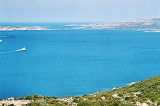
Cugnana gulf is a natural bay that is entered between Marina di Portisco and Nuraghe point. Internally there are two landing piers with privately managed (Porto Asfodeli and Marina di Cugnana).
To the south of the bay, the depth of weed and mud, is low (0,5 m) and go down toward ...


 Petra Ruja or Liscia Ruia cove offers an arc shaped pebble beach.
 L'anse Petra Ruja ou Liscia Ruia offre une plage de galets en forme d'arc.
 Cala Petra Ruja o Liscia Ruia ha una spiaggia a forma di arco, fatta di ciottoli.
 (Sardegna)")
 (Sardegna)")
 (Sardegna)")