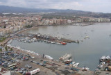
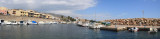
The port extends between two jetties. The pier of the E (Levante) starts near the San Jacinto factory. Pier W (Poniente) starts from a point of the coast located 500 m SW of the root of the pier of the E. The width of the entrance is 170 m and the depth of 14 m on sandy bottom, decreasing to 1.5 or 3.5 inside the port. Good shelter.
250 pl. (<12 m)
Depth. 4 m
T. (+34) 950 13 24 10
F: (+34) 950 13 23 15
Mail: pdgarrucha@distrito.com
2019/06/6
Update
xatb
Le port s'étend entre deux jetées. La jetée de l'E (Levante) s'amorce près de l'usine de San Jacinto. La jetée W (Poniente) part d'un point de la côte situé à 500 m au SW de l'enracinement de la jetée de l'E. La largeur de l'entrée est de 170 m et la profondeur de 14 m sur fond de sable, diminuant à 1,5 ou 3,5 à l'intérieur du port. Bon abri.
250 pl. (< 12 m)
Prof. 4 m
T. (+34) 950 13 24 10
F: (+34) 950 13 23 15
Mail: pdgarrucha@distrito.com
2008/03/8
Update
Share your comments or photos on "Puerto de Garrucha (Murcia)"
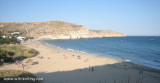
Small fisherman's port at the foot of Sierra Cabrera, well sheltered. From all the beach of Carboneras one sees the island of San Andrés, small rocky island of 1,5 hectares whose silhouette on the horizon evokes that of a whale.T. 950 13 07 39F. 950 23 29 49Mail: www.eppa.es679 pl.
Cette anse est abritée des vents d'E. Devant le village et au centre de l'anse, un banc de sable, avec des profondeurs de 5 m s'étend à 200 m du rivage.
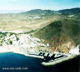
The rocky promontory of Las Aguilas separates the port of Poniente located at the W, the port of Aguilas proper located at E. The port of poniente is used only for the consruction and the beaching of the fishing boats. The depths are variable.The port of Aguilas lies between Negra ...
Mount Cope is a rocky promontory, steep, reddish, 250 m high. It has a front 0.75 mile long between the points of Penon de Santa Maria in SW and Cerro de la Cruz NE. The first point forms the E end of Bardina Cove where there is a good anchorage well sheltered from E winds.Near ...
The natural harbor of San Pedrose is located near a village with a castle. By strong SW winds, avoid this port. Great restaurants at the port or you can enjoy very good fish, animations and circus atmosphere of the evening near the beach in town, clown show, fire etc. ... T. ...


 Canal 9


 école de voile
")
")
 The port extends between two jetties. The pier of the E (Levante) starts near the San Jacinto factory. Pier W (Poniente) starts from a point of the coast located 500 m SW of the root of the pier of the E. The width of the entrance is 170 m and the depth of 14 m on sandy bottom, decreasing to 1.5 or 3.5 inside the port.
 Le port s'étend entre deux jetées. La jetée de l'E (Levante) s'amorce près de l'usine de San Jacinto. La jetée W (Poniente) part d'un point de la côte situé à 500 m au SW de l'enracinement de la jetée de l'E. La largeur de l'entrée est de 170 m et la profondeur de 14 m sur fond de sable, diminuant à 1,5 ou 3,5 à l'intérieur du port.