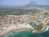
Algar de Almadraba (C Valenciana)
9.9nm
298°
23 May 12
Jojo
| Latitude | Longitude | |
| DMS | --- | --- |
| DM | --- | --- |
| DD | --- | --- |


")
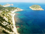
") Windmills of the cape
Windmills of the cape Cabo de San Antonio, located 0.7 mile ENE of Javea, is formed by a high and level promontory (160 m) which falls steeply towards the sea. The Mongo Mount (761 m), 3NM W the cape, is the cumination point of the region. From a distance, on clear days, it appears as an island, but by E or NE wind it is hidden by clouds. It overlooks a range of hills that extends eastward in an horizontal plate to Cape San Antonio.
 Cabo de San Antonio, situé à 0,7 MN à l'ENE de Javea, est un haut promontoire (160 m) qui tombe abruptement vers la mer.
Ibiza est l'île proche des Îles Baléares, qui s'étend à 48 MN à l'ENE du cap San Antonio.
Courants: Les forts vents de NE produisent un courant portant en côte qui a pour effet d'élever le niveau de l'eau. Ce courant se dirige vers le cap de San Antonio, le dépasse, continue au S ou au SE et rejoint le courant E général. Sa vitesse n'exéde pas généralement 2 ou 3 noeuds.
Pareil courant, observé par beau temps, annonce que le vent va tourner au NE ou au SE.
Inversement, avec des vents de NW, il se forme un courant portant au large qui abaisse le niveau de l'eau, se dirige vers les Baléares et dévie en partie vers le S pour rallier le courant général.
Ebook | Espagne Est - East Spain
|