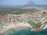
Javea, a small harbor, is situated within a bay, 2.4 miles NNW of Cabo de San Martin. It is protected by two breakwaters and is used by small craft and yachts.
Good shelter.
T. 96 579 1025
F. 96 579 6008
M. cnjavea@terra.es
379 b.
Depth: 7 m
Anchorage can be obtained, in depths of 14 to 20m, sand, E of the harbor.
Caution.—Submarine cables extend E from a point on the shore lying close S of Javea.
Algar de la Almadraba, centered about 6 miles NW of Denia, is an extensive area of foul ground which lies off this stretch of coast. This area has depths of 25 to 36m and heavy seas are raised over it by onshore winds.
Beyond Cape San Martin extends the Javea cove to Cape San Antonio. This cove is exposed to winds from SE and NE.
The town of Javea, located in the N of the loop is built on a hill at 0.8 NM from the shore. It overlooks the Rio Jalon or Gorgos that opens near and ...
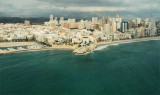
Ensenada de Benidorm lies between Cabezo del Tosal and Punta de la Escaleta, 3 miles E. the small hill Canfali, which forms a promontory in the center of the cove of Benidorm, divides the coast into two splendid sandy beaches, the Levant and the Ponant.
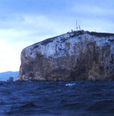
Cabo de San Antonio, located 0.7 mile ENE of Javea, is formed by a high and level promontory (160 m) which falls steeply towards the sea. The Mongo Mount (761 m), 3NM W the cape, is the cumination point of the region. From a distance, on clear days, it appears as an island, but ...
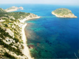
N Nao cape, Portichol bay opens between two projecting points, at S the Negro Cape and San Martin Cape at N. The coast is steep and steep except for a small beach.
Front of the bay, the island of Portichol and a rock at his side ...


 Canal 9


 Javea, a small harbor, is situated within a bay, 2.4 miles NNW of Cabo de San Martin. It is protected by two breakwaters and is used by small craft and yachts.
 ")
")
 Situé au bas de la face S du Cap San Antonio, Javea est un port bien abrité du vent, à proximité d'Ibiza.