N Nao cape, Portichol bay opens between two projecting points, at S the Negro Cape and San Martin Cape at N. The coast is steep and steep except for a small beach.
Front of the bay, the island of Portichol and a rock at his side S are separated from the coast by a passage impracticable.
2012/05/22
Update
Jojo
Este fondeadero es de roca, por lo que es fácil enganchar el ancla. Hay que tener especialmente a una zona de bajos que en días de mar tranquilo no rompe el mar y entonces es difícil percibirlas
2013/09/23
Update
Marce Luis Alonso
Au N du cap de La Nao, la baie de Portichol s'ouvre entre deux pointes saillantes, le cap Negro au S et le cap de San Martin au N. La côte est escarpée et à pic si l'on excepte une petite plage.
Devant la baie, l'île de Portichol et un rocher à son côté S sont séparés de la côte par un passage impraticable.
Algar de la Almadraba, centered about 6 miles NW of Denia, is an extensive area of foul ground which lies off this stretch of coast. This area has depths of 25 to 36m and heavy seas are raised over it by onshore winds.
Beyond Cape San Martin extends the Javea cove to Cape San Antonio. This cove is exposed to winds from SE and NE.
The town of Javea, located in the N of the loop is built on a hill at 0.8 NM from the shore. It overlooks the Rio Jalon or Gorgos that opens near and ...
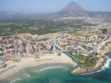
Ensenada de Benidorm lies between Cabezo del Tosal and Punta de la Escaleta, 3 miles E. the small hill Canfali, which forms a promontory in the center of the cove of Benidorm, divides the coast into two splendid sandy beaches, the Levant and the Ponant.
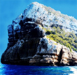
Cabo Negro, located 1 mile N of Cabo de la Nao, is sheer cut and fronted by rocks. Isla del Portichol, 68m high, lies close offshore, 0.7 mile N of this cape.This site of diving deep (20 m) offers stacks of arches, caves and passages.


 N Nao cape, Portichol bay opens between two projecting points, at S the Negro Cape and San Martin Cape at N. The coast is steep and steep except for a small beach.
 Au N du cap de La Nao, la baie de Portichol s'ouvre entre deux pointes saillantes, le cap Negro au S et le cap de San Martin au N. La côte est escarpée et à pic si l'on excepte une petite plage.
")
")