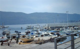
Zelekina port was damaged by the earthquake of 1979. It only remains now a dock for formalités.Port Customs official entry, the platform is protected by rubber fenders.
2011/04/9
Update
dd
Le port de Zelekina a été endommagé par le tremblement de terre de 1979. Il ne reste plus maintenant qu'un quai des douanes pour les formalités.Port d'entrée officiel, le quai est protégé par des défenses en caoutchouc.
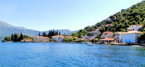
The middle bay of Boka Kotorska, is connected to Topaljski Zaliv by Kumborski Strait, a deep passage. This bay is steep and rocky on its S side, but the NE and NW shores, which are backed by mountains, are low and cultivated. Uvala Kukuljina and UvalaKrtole, separated from each ...
Rose Village is located right on entering the Bay of Kotor, on the Peninsula Lustica. It is surrounded by forbidden zones (a zone that extends to the SW of the pier fire Rose, near the entrance of Kotor Bay and another area that participated in the Ede Spilice up Tivaski Zaljev) ...
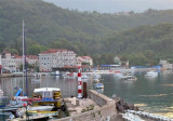
Herceg Novi is located N of the entrance of Bay of Kotor on the coast N Hercegnovi Zaljev. It is a popular seaside resort with bars near the port that make port noise. The port is the subject of a constant traffic of tour boats and ferries, which operate late at night and create ...
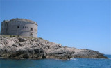
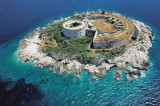
Mamula is strategically located between Prevlaka and Luštica peninsulas on the entrance to the Boka Kotorska bay. This small islet is of circular shape, and is 200m in diameter. It is 3.4 nautical miles away from Herceg Novi.There is a fort on the island, built by Austro-Hungarian ...


 Zelekina port was damaged by the earthquake of 1979. It only remains now a dock for formalités.Port Customs official entry, the platform is protected by rubber fenders.
 Le port de Zelekina a été endommagé par le tremblement de terre de 1979. Il ne reste plus maintenant qu'un quai des douanes pour les formalités.Port d'entrée officiel, le quai est protégé par des défenses en caoutchouc.