
Key Biscayne (Miami)
8nm
191°
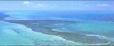
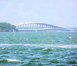
Bay. It is the southernmost of the barrier islands along the Atlantic coast of Florida, and lies south of Miami Beach and southeast of Miami. The Key is connected ...
18 Apr 12
JB
| Latitude | Longitude | |
| DMS | --- | --- |
| DM | --- | --- |
| DD | --- | --- |

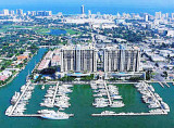
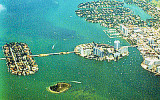
 Miami Beach occupies the barrier beach that separates the ocean from the upper part of Biscayne Bay and is also an important yachting center. A number of causeways, with bridges over the channels, form good highway connections with Miami and the mainland communities.
A fishing pier extends out into the sea about 0.3 mile north of the jetties. Miami Beach Coast Guard Base and a commercial terminal are northward of the main ship channel near the east end of the MacArthur Causeway.
Miami Beach City Yacht Harbor is on Meloy Channel at the southwestern end of Miami Beach.
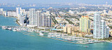
Numerous tall buildings and hotels along the oceanfront at Miami Beach are visible for miles in all directions. A very prominent landmark in Miami Beach is the tall green and black building of a saving and loan company at about 25°47'26"N., 80°07'56"W., on which the red obstruction lights and an illuminated time and temperature sign, flashing from 7 a.m. to midnight, can be seen over 16 miles offshore.
A tall stack and water tank on Virginia Key, Cape Florida Light, the aviation light at Miami International
Airport, a number of radio and television towers, and numerous other tanks and towers are also prominent.
 Miami Beach occupe la plage barrière qui sépare l'océan de la partie supérieure de la baie de Biscayne et c'est aussi un centre nautique important. Un certain nombre de chaussées, avec des ponts au-dessus des canaux, forme les raccordements routiers avec Miami et les communautés du continent.
Un quai de pêche s'étend dans la mer à environ 0,3 mile au nord de la jetée. Miami Beach, Base de la Garde côtière, et un terminal commercial sont au nord du chenal de navigation principal près de l'extrémité E de la Mac Arthur Causeway.
Miami Beach City Yacht Harbor est située à
Meloy Channel, à l'extrémité SW de Miami Beach.
De nombreux immeubles de grande hauteur et des hôtels le long du front de mer à Miami Beach sont visibles sur plusieurs miles dans toutes les directions. Un point de repère très important dans Miami Beach est le grand bâtiment vert et noir d'une épargne et de prêt à environ 25 ° 47'26 "N., 80 ° 07'56" O., sur lequel les feux d'obstacle rouges, une fois éclairés avec les chiffres de la température, clignotent de 7 h à minuit. On peut les voir à plus de 16 miles au large des côtes.
Une grande cheminée et le réservoir d'eau sur Virginia Key, Cape Florida Light, les lumières de Miami International Aéroport, un certain nombre de radios et de tours de télévision, et de nombreux autres réservoirs et tours sont également remarquables.
Ebook | US - East coast
|