Key Biscayne (Miami)

Key Biscayne (Miami)

To precisely geolocate this site. Update if necessary.

Localisation

Key Biscayne (Miami)
LatitudeLongitude
DMS------
DM------
DD------

Characteristics

Coast

Description

Key Biscayne (Miami)
2010-04-05
Update
Joëlle
Ebook

US - East coast

  • 184 sites
  • 66 photos
  • publication date: 8 Jul 2023
  • .pdf file size: 128 Mb
Key Biscayne is an island located in Miami-Dade County, Florida, United States, between the Atlantic Ocean and Biscayne
Bay. It is the southernmost of the barrier islands along the Atlantic coast of Florida, and lies south of Miami Beach and southeast of Miami. The Key is connected to Miami via the Rickenbacker Causeway, originally built in 1947.

The northern portion of Key Biscayne is home to Crandon
Park, a county park. The middle section of the island consists of the incorporated Village of Key Biscayne. The southern part of the island is in Bill Baggs Cape Florida State
Park, and is adjacent to Biscayne National Park, one of the two national parks in Miami-Dade County.

Key Biscayne, although named a "key", is not geologically part of the Florida Keys, but is a barrier island composed of sand eroded from the Appalachian Mountains, carried down to the coast by rivers and then moved down the coast from the north by coastal currents.

Key Biscayne is elongated in the north-south direction, tapering to a point at each end. It is approximately five miles (eight kilometers) long and one to two miles (one-and-a-half to three km) wide. The northern end of the island is separated from another barrier island, Virginia
Key, by Bear Cut. The southern end of the island is Cape Florida.
The Cape Florida Channel separates the island from the Safety Valve, an expanse of shallow flats cut by tidal channels that extends southward about nine miles (fourteen-and-a-half km) to the Ragged
Keys, at the northern end of the Florida Keys.

Key Biscayne is connected to the mainland by a bridge-causeway which crosses Bear Cut, Virginia Key, and Biscayne Bay. The highway bridge over Bear Cut has a 48-foot fixed span with a clearance of 16 feet.

A shoal, reported bare at mean high water, extends about 0.6 mile in a north-south direction about 0.2 mile off the eastern shore of Key Biscayne.

2012/04/18
Update
JB
Rickenbacher bridge.
2010/04/5
Update
Joëlle
Key Biscayne est une île située dans le comté de Miami-Dade , en Floride , Etats-Unis , entre l' océan Atlantique et la baie de Biscayne. C'est la plus méridionale des îles-barrières le long de la côte Atlantique de la Floride, elle se trouve au sud de Miami Beach et au sud de Miami. La clé est reliée à Miami par le pont-jetée de Rickenbacker, construit en 1947.

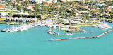
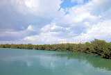
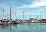
La  partie nord de Key Biscayne est le foyer de Crandon Park , un parc du comté. La section centrale de l'île abrite le village de Key Biscayne. La partie sud de l'île est le Cape
Florida State Park , et est adjacente au Parc national de Biscayne , l'un des deux parcs nationaux de Miami-Dade County.

Key Biscayne, bien que nommé «clé», ne fait pas géologiquement partie des Florida Keys , mais est une île-barrière composée de sable érodé de la chaîne des Appalaches transporté jusqu'à la côte par les rivières et déplacé vers le bas de la côte N par les courants côtiers.

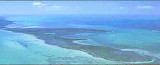
Key Biscayne est allongée dans le sens nord-sud, se terminant en pointe à chaque extrémité. Elle mesure environ cinq miles (huit kilomètres) de long et un à deux miles (un et demi à trois km) de large. L'extrémité nord de l'île est séparée d'une autre île-barrière, Virginia Key, et Bear passage. L'extrémité sud de l'île est le Cap de la Floride. Le Cape Florida Channel sépare l'île de Safety Valve, une étendue de chenaux peu profonds coupées par des chenaux de marée qui s'étendent vers le sud à environ neuf miles (quatorze km et demi ) à Keys Ragged , à l'extrémité nord des Florida Keys .

Key Biscayne est reliée au continent par un pont-chaussée qui traverse Bear Cut,
Virginia Key, et de la baie de Biscayne. Le pont routier sur Bear Cut a une hauteur fixe de 14,4 m avec un dégagement de 4,8 m.

Un haut-fond, recouvert par marrée haute, s'étend environ 0,6 mile dans une direction NS d'environ 0,2 mile au large de la côte E de Key
Biscayne.

2012/04/18
Update
JB
Share your comments or photos on "Key Biscayne (Miami)"

Sites around Key Biscayne (Miami)

Flying distances - Direct line

Elliot Key (Florida)

15nm
188°
Elliott Key is the northernmost of the true Florida
Keys (those 'keys' which are ancient coral reefs lifted above the present sea level), and the largest key north of Key
Largo. It is located entirely within Biscayne National Park.
It is bordered by the Atlantic Ocean to ...
18 Apr 10
Joëlle

Miami Beach (Florida)

8nm
12°
Miami Beach occupies the barrier beach that separates the ocean from the upper part of Biscayne Bay and is also an important yachting center. A number of causeways, with bridges over the channels, form good highway connections with Miami and the mainland communities.
The city is ...
8 Apr 10
Joëlle

Key Biscayne Yacht Club (Key Biscayne)

0.3nm
251°
Located South of West Point, on the western shores of Key Biscayne.Tel: (305) 361 9171
Fax: (305) 361 9209
Mail: receptionist@kbyc.org100 slips (<60')
Minimum depth: 10 foot
18 Apr 12
JB

No Name Harbor (Key Biscayne)

1.4nm
178°
Located on the waters of the tadpole-shaped harbor, which indents the westerly banks of south Key Biscayne, near
Cape Florida.The minimum depth is 10 feet and the shelter is excellent.
There is an overnight anchorage fee of $15.00, and a day use fee of $2.00.
It will be necessary ...
18 Apr 12
JB

Crandon Park Marina (Key Biscayne)

1.5nm
15°
Crandon
Park Marina is on Key Biscayne lies on the eastern coast of Florida in the south of the USA. It is a Dade County Municipal Marina and lies in the 900 acre Crandon Park. The facility combines slips & moorings.
Crandon Park Marina lies on the northern end of Key Biscayne, ...
18 Apr 12
JB

Cape Florida Anchorage (Key Biscayne)

2nm
177°
Cape Florida Anchorage, with depths of 12 to 20 feet, is about 300 yards westward of the south end of Cape Florida with the lighthouse tower bearing northward of 069°. This is a poor anchorage with southerly winds.
18 Apr 12
JB