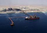

Puerto de Mejillones del Sur (Antofagasta N Chile)
3.9nm
206°
21 Dec 12
Joëlle
| Latitude | Longitude | |
| DMS | --- | --- |
| DM | --- | --- |
| DD | --- | --- |

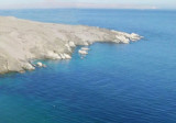
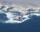
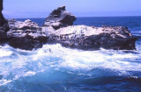
 Bahia Mejillones is entered between Punta Chacaya and Punta Angamos.
The approaches to the bay are clearly depicted by radar from a distance of about 30 miles. Punta Angamos, Punta Chacaya, Morro Mejillones, and Tetas de Mejillones serve as excellent radar landmarks.
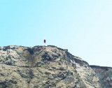
Morro Mejillones has the appearance of a truncated cone and stands conspicuously above the surrounding heights. In clear weather this is the best landmark in the vicinity, but as the tops of the hills on this coast are frequently covered with heavy clouds, Punta Angamos is a surer mark. Besides a chalky appearance, it is the N extremity of the peninsula.
Tetas de Mejillones consist of two peaks, 325 and 330m high, on the W shore of the bay about 1.5 miles S of Punta Angamos.
")
 Bahia Mejillones se trouve entre Punta Chacaya et Punta Angamos.
Les approches de la baie se distinguent parfaitement au radar, depuis 30 MN au large. Punta Angamos, Punta Chacaya, Mejillones Morro, et tetas Mejillones servent de points de repère radar excellents.
Morro Mejillones a l'apparence d'un cône tronqué et s'élève d'une façon remarquable au-dessus des hauteurs environnantes. Par temps clair c'est le meilleur repère des environs, mais malheureusement le sommet des collines sur cette côte, sont fréquemment couverts de nuages, Punta Angamos est un amer sûr. Sous son apparence crayeuse c'est l'extrémité N de la péninsule.
Tetas de Mejillones est composé de deux pics, de 325 et 330 m de haut, sur le côté W de la baie, à environ 1,5 MN au S de Punta Angamos.
Ebook | Chile
|