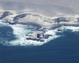
Isla Guaman is about 21.9m high and white. Rocks extend nearly 0.1 mile NW from the NW end of the island and shoals extend about 91m off all other sides of the island.
It is connected to the mainland by a causeway.
A beacon, 6m high, equipped with a can-shaped topmark with red and white bands, stands on Isla Guaman.
2012/12/23
Update
Joëlle
Isla Guaman est haute d'environ 21,9 m et blanche. Des rochers s'étendent rès d'elle sur 0,1 MN au NW à partir de l'extrémité NW de l'île et des bancs s'étendent sur environ 91 m au large à partir de toutes les autres côtés de l'île.
L'île est reliée au continent par une chaussée.
Une balise de 6 m de haut, équipée d'un voyant en forme de boite avec des bandes rouges et blanches, se dresse sur l'île.
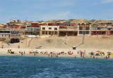
Caleta La Chimba lies NE of Isla Guaman and is protected from the S by a causeway joining the island to the mainland. There are depths of 25 m in the entrance, which decrease to about 9 m about 0.2 NM from the head of the cove. Beware, above-water rocks lie about 0.3 NM ...
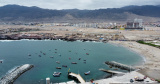
Antofagasta lies E side of Rada de Antofagasta. It is the larger commercial port of N Chile. A large part of the import-export trade of Bolivia passes through the port. Bolivia maintains a customhouse here. The harbor is well-protected and large vessels berth alongside ...
Santa Maria island is between caleta Constitucion and caleta Errazuriz. Reefs extend a little over 0.5 mile SSW from the S side of the island and up to 0.3 mile from all other sides.


 Isla Guaman is about 21.9m high and white. Rocks extend nearly 0.1 mile NW from the NW end of the island and shoals extend about 91m off all other sides of the island.
  Isla Guaman est haute d'environ 21,9 m et blanche. Des rochers s'étendent rès d'elle sur 0,1 MN au NW à partir de l'extrémité NW de l'île et des bancs s'étendent sur environ 91 m au large à partir de toutes les autres côtés de l'île.
")
")
")
")
")