Otok Ciovo
2.4nm
119°
O. Ciovo forms the SW side of the entrance and inner part of Kastelanski Zaliv.
At East side, Ciovo is 2km from ...
7 Aug 11
cdg2
| Latitude | Longitude | |
| DMS | --- | --- |
| DM | --- | --- |
| DD | --- | --- |

 canal 17


 Konzum après le 2ème pont, face au marché
 marché, marché aux poissons


Ebook | Splitsko-dalmatinska županija (Split-Dalmatia Coun
|
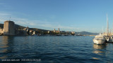
 Trogir town lies on a small island between the continent at the N and S O. Ciovo.
Yachtmen find good facilities at the marina, but beware it is closed to visitors Friday boats as charter boats take center stage.
Approach: If you have a vertical clearance of over 2.4 m you can not pass under the bridge connecting O. Ciovo Trogir to the mainland.
We arrive in Trogir by W, the marina and the main wharf of Trogir is located on the W of the bridge.
Rt Okruk since there is no danger in the approach to near Rt Cubrijan which carries a light.
The mainland coast N of Rt Cubrijan is shallow, as the area S of Rt Cubrijan.
Stay in the middle of the fairway to Trogir. There is a buoy without fire in the channel N, W to the castle. The channel has funds of 11 m at the entrance and 4 m near the bridge.
Sometimes there may be a strong current (up to 3 knots) under the bridge which is normally the W.
The best location is at the marina, but you can also go along the quay of the city avoiding the ferry berth.
Petrol pump is available at the entrance of the Marina on the south/West side.
Good protection.
Marina Tel: +385 (0) 21 881 544
Marina Fax: +385 (0) 21 881 258
Mail: @ aci-m.trogir club.hr
180 b. (<18 m)
TE Max: 5.5
 La ville de Trogir occupe une petite île entre le continent au N et O. Ciovo au S.
Les plaisanciers trouvent de bonnes installations à la marina, mais attention elle est fermée aux bateaux visiteurs le vendredi car les bateaux de charter prennent toute la place.
Approche: Si vous avez un tirant d'air de plus de 2,4 mvous ne pouvez pas passer sous le pont reliant O. Ciovo au continent à Trogir.
On arrive à Trogir par l'W, la marina et le quai principal de Trogir se trouvent à l'W du pont.
Depuis Rt Okruk il n'y a pas de danger dans l'approche jusqu'à proximité de Rt Cubrijan qui porte un feu.
La côte continentale au N de Rt Cubrijan est peu profonde, tout comme la zone au S de Rt Cubrijan.
Rester au milieu du chenal jusqu'à Trogir. Il y a une bouée sans feu au N du chenal, à l'W du château. Le chenal a des fonds de 11 m à l'entrée et de 4 m près du pont.
Quelque fois il peut y avoir un fort courant (jusqu'à 3 nœuds) sous le pont qui porte normalement à l'W.
Le meilleur emplacement est à la marina, mais on peut aller aussi le long du quai de la ville en évitant le poste d'amarrage du Ferry.
Bonne protection.
Tel marina: +385(0)21 881 544
Fax marina: +385(0)21 881 258
Mail: m.trogir@aci-club.hr
180 pl (<18 m)
TE maxi: 5,5