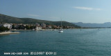
Quay along the old city mailnly reserved for big units. Smaller ships has to use the facility of the ACI Marina opposite on the Ciovo island.
The city must be visited.
Small grocery on the quay. For major shopping go north outside the city, cross the bridge, opposite a supermarket and the local market for fruits and fishes.
Ciovo is an island in the center of the Dalmatian archipelago. This is an area of 28.8 acres (15.3 km length, width of 3.5 km). It culminates at 218 m (Mount Rudin). O. Ciovo forms the SW side of the entrance and inner part of Kastelanski Zaliv. At East side, Ciovo is 2km from ...
Island accessible only by sea. It is long about 3 m long by 2 m wide. It is 2 M NW of otok Solta.Its area is 12.07 km ² and its highest point is 178 m.It is separated from the mainland by Drvenicki Kanal. The coast of this beautiful island has remained intact and is made of many ...
Otok Zirje
is the farthest and the largest island in the Sibenik archipelago. It is long of 6,5 NM (NW/SE) and 1,4 NM wide. The main village, Zirje, is located in the middle of the island. A small port, luka Muna, on the coast N of Zirje, home to the ferry that connects the ...
Plakeni islands, or Cursed Islands, are located at the W and S of Hvar town.
The islands are rocky, covered with bushes and trees. They are usually deserted, except in summer. They offer many choices of moorings sheltered and there is a marina Palmizana.The islands'name ...
Anchoring possibilities on the East side of Trogir. The bridge cannot be open, you will not be able to pass to the West of the city and join the ACI Marina.


 Quay along the old city mailnly reserved for big units. Smaller ships has to use the facility of the ACI Marina opposite on the Ciovo island.
 Superbe village à découvrir. Escale obligatoire.