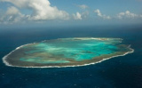

Reserva Biológica Atol das Rocas
84nm
268°
21 Feb 21
azerty
| Latitude | Longitude | |
| DMS | --- | --- |
| DM | --- | --- |
| DD | --- | --- |


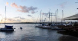
 It is a natural anchorage place, just off the breakwater, which provides protection for the dinghy when landing.
However, this anchorage is reported to be rolly. In the winter months
(July) the seas here are generally calm.
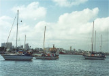
It is a natural anchorage place, just off the breakwater, which provides protection for the dinghy when landing.
However, this anchorage is reported to be rolly. In the winter months
(July) the seas here are generally calm.Anchor in 10 to 14m over hard sand (and rock).
")
Ebook | NE Brazil
|
Ebook | SW Atlantic Ocean
|