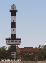

East Coast of India
209nm
289°
9 Aug 21
Ayush
| Latitude | Longitude | |
| DMS | --- | --- |
| DM | --- | --- |
| DD | --- | --- |

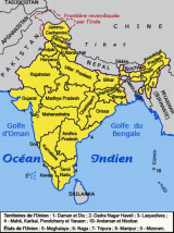
 The Bay of Bengal (largest bay in the world,) forms the northeastern part of the Indian Ocean. It is bordered mostly by the Eastern Coast of India, southern coast of Bangladesh and Sri Lanka to the west and Burma (Myanmar) and the Andaman and Nicobar Islands (part of India) to the east.
On the East, a line running from Cape Negrais in Burma through the larger islands of the Andaman group, in such a way that all the narrow waters between the islands lie to the Eastward of the line and are excluded from the Bay of Bengal, as far as a point in Little Andaman Island and thence along the Southwest limit of the Burma Sea [A line running from Oedjong Raja in Sumatra to Poeloe Bras (Breuëh) and on through the Western Islands of the Nicobar Group to Sandy Point in Little Andaman Island, in such a way that all the narrow waters appertain to the Burma Sea].
On the South. Adam's Bridge (between India and Ceylon [Sri Lanka]) and from the Southern extreme of Dondra Head (South point of Ceylon) to the North point of Poeloe Bras.The islands in the bay are very numerous, including the Andaman, Nicobar and Mergui groups. The group of islands, Cheduba and others, in the north-east, off the Burmese coast, are remarkable for a chain of mud volcanoes, which are occasionally active. Great Andaman is the main archipelago or island group of the Andaman Islands, whereas Ritchie's Archipelago consists of smaller islands. Only 37 of the 572 islands and islets of the Andaman and Nicobar Islands are inhabited, or 6.5%.
Major Bangladesh ports on the bay include Chittagong and Mongla. Major Indian ports on the bay include Krishnapatnam, Chennai (formerly Madras), Vishakhapatnam, Kolkata (formerly Calcutta), and Pondicherry. Yangon, the largest city and former capital of Myanmar is also an important port in the bay.Kokalta and Chennai are the biggest ports in the world.
The monsoon currents regulate the climate of the Bay of Bengal and the
regions around it.
During the months of January to October, the current
flows towards the north in a clockwise circulation pattern and is called
the East Indian Current.
The Bay of Bengal monsoon moves in a northwest
direction hitting the Andaman and Nicobar Islands at the end of May and
then the North Eastern Coast of India by the end of June.
Throughout
the remaining part of the year, a counter-clockwise current flows
towards the southwest direction, and is called the East Indian Winter
Jet.
During the months of September and December the weather is very
active. The monsoon season often brings in severe cyclones, which affect
Eastern India as well as parts of other countries. The 1971 Orissa cyclone is one of the worst.

Ebook | Bay of Bengal
|