
Pamban Island (E India)
200nm
357°
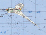
The chain formed by Pamban Island, the shoals of Adam's Bridge, and Mannar Island of Sri Lanka separate Palk Bay ...
20 Mar 12
Jojo
| Latitude | Longitude | |
| DMS | --- | --- |
| DM | --- | --- |
| DD | --- | --- |

 Palk Bay, the continuation S of Palk Strait, is bounded on the E by the coast of Sri Lanka, on the S by Mannar Island, Adam’s Bridge, and Pamban Island, and on the W by the coast of India.
The bay has general depths of 11 to 12.8m, but on its E side depths of 9.1m and less extend up to 15 miles from the coast of Sri Lanka, and within it are several islands, rocks, and shoals.
On the S side of the bay depths of less than 9.1m extend up to 7 miles from the coast. The NW part of the bay has not been fully surveyed.
Caution.—Dangerous wrecks and other hazards to navigation in Palk Strait are best seen on the chart.
Ebook | Bay of Bengal
|