Pyramid Shoal, which lies on the N side of the SE end of South Sands, has a least depth of 3.4m, hard sand, and is the most dangerous shoal in the area because of its depth and protrusion into the fairway. A lighted buoy is moored about 7 miles SE of Pyramid Shoal. A depth of about ...
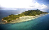
Between Melaka and Tanjong Seginting, about 46 miles SE, the low, thickly wooded coast is bordered by a mud bank which extends up to 2.5 miles offshore in places. The Water Islands, centered about 8 miles SE of Melaka, consists of a group of six tree-covered islands of moderate ...
Batu Tengah, marked by a light, consist of three rocks just above-water, lying about 2 miles SE of Batu Mandi and about 1 mile offshore. A shoal, with a depth of 14.3m lies about 6 miles SSW of Batu Mandi.
Sungai Linggi is indented by a shallow bay. Good anchorage can be taken off the river entrance, in a depth of 16.5m, mud, with Tanjong Tuan Light bearing 292° and the beacon in the entrance of the river bearing 075°.
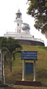
Tanjung Tuan, also called Cape Rachado,
is the site of the oldest - and still functioning - lighthouse in
Malaysia. Cape Rachado Lighthouse, also called Rumah Api Tanjung Tuan,
was built somewhere between 1528 and 1529 by the Portuguese to help
guide ships to the Malacca port. ...
Pulau Batu Besar, 4.6m high, stands 1.25 miles offshore, 7 miles SE of Batu Tengah. A sandy ridge, with depths of 6.1 to 9.7m, lies from 0.5 to 2 miles NW of the rock. A shoal with a depth of 16.3m, lies 3.5 miles WSW of Pulau Batu Besar. Two white towers, each about 34m high, ...


 Batu Mandi, a rock, awash, marked by a beacon, lies about 2 miles SW of the S entrance point of the Sungai Linggi.