Merodong group (Indonesia)
6nm
155°
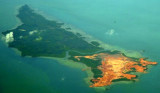
Merodong, the ...
10 Feb 12
Jojo
| Latitude | Longitude | |
| DMS | --- | --- |
| DM | --- | --- |
| DD | --- | --- |

 The Titampan group of islands, located NW of the Merodong group, occupies an oval space about 6 miles in length, E and W, and nearly 5 miles in breadth. It comprises several islands, islets, and rocks, which are separated from each other by narrow channels which are obstructed by reefs.
Pulau Titapan, the SW island and most conspicuous of the group, is rocky on its N and S sides and has two hills; the N hill is sharp and 108m high.
A 5.5m patch, which is steep-to, lies about 0.4 mile SW of Titapan.
Pulau Benan, 3.5 miles NW of Pulau Mesanak, is the easternmmost island of a group which separates Selat Merodong and Selat Pengelap. It is 2 miles long, tapering at both ends, and is 0.75 mile wide near the middle. The island is easily recognized by a conspicuous hill, it is 67m high, at its SE end.
A reef fronts the greater part of Benan, extending from 0.25 to 0.5 mile off the N and NE sides.
Pulau Katanglingga, l.5 miles NW of Benan, is a bold bluff-looking island 1 mile long and 50m high at the N end; the S end is low. A reef fronts the greater part of it, extending in some places to a distance of about 0.2 mile.
With onshore winds, a heavy sea runs up on the E side of Benan and Pulau Katanglingga.
Pulau Benan and Katanglingga form the E limit of the group.
Ebook | Sumatra (Indonesia)
|