Merodong group (Indonesia)
5.3nm
257°
Merodong, the ...
10 Feb 12
Jojo
| Latitude | Longitude | |
| DMS | --- | --- |
| DM | --- | --- |
| DD | --- | --- |

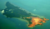
 Pulau Mesanak, located 7 miles N of the N end of Pulau Sebangka, has the form of an elbow, of which the long arm extends 4.5 miles in a N and S direction, and the short arm 3 miles E and W. Ridges of hills extend the whole length of both arms, the highest point, 107m high, being where the arms meet.
Two rocks which cover at HW lie nearly 0.5 mile off the N side of the island and about 1 mile E of Observation Point, the NW extremity of the island.
Patches of 6.9m lies about 0.1 mile NW of the above-mentioned rocks and about 0.2 mile N of Observation Point.
West of the island, foul ground extends W of Merodong Is land and other islands.
Pulau Mesanak forms the S side of the entrance to Selat Merodong, and the W side of approach to Selat Riau.
Ebook | Sumatra (Indonesia)
|