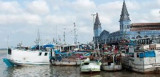
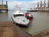
The port of Sao Luishas silted up and has ceased to be important as a port after the construction of the port of Itaqui. The port of Sao Luis is used mainly by fishing boats and pleasure craft. It has a few piers that allows mooring, but only at flood tide, to ships of 2,5 to 3,5 draft.
Cruisers are urged to take precautions if visiting this port. Policia Federal (immigration) and Customs are at the port
entrance.
The historical center is at 30 minutes drive away.
Anchor south of Itaqui, near all the pilot boats and tugs. Good
holding in mud. It is possible to tie the dinghy near a sloping ramp
and climb the slippery steps to get ashore.
There is a sort of marina, Marina Aven, which appears to
dry out completely at low water and thus only suitable for catamarans or
others who can sit on the bottom. They have a dock space for four
yachts and (rain?) water is available.
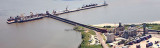
Located on the coast of São Luís, the state capital, the port has a deep
access channel and berths, enabling the mooring of large ships. Port of Itaqui is the largest cargo port in Brazil, near the city of São Luís, Maranhão. It is not to be confused with the city of Itaqui, ...
The port of Belem is the most important commercial port on the N coast of Brazil. The port is situated on the E bank of the Rio Para about 70 miles from its mouth. Communication is maintained with all inland Amazon ports.
This is the best port at which to enter Amazonia, but ...
Vila do Conde has a causeway extending 450m from the shore leading to a jetty which serves an aluminum factory. The outer berth is 292m long and is used for handling bulk cargo. The inner berth is 251m long and is used for handling general cargo and aluminum ingots. The depths alongside ...
Stands on the W bank of the rio Tocantins, about 90 NM from Belem. The town is built on the river bank and is an important trade center. The tidal range is about 3m; the current attains a rate of about 2.5 knots.
This is the most important city on the north coast and is also a busy fishing harbour.
For the unsuspecting, the bay is littered with wrecks (those not buoyed
show above the water), and the water shallows quickly, so care should be
taken on entry. Lights on the buoys can ...
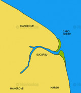
Cabo Norte is the limit of the estuary of the Amazon river. It is 19 NM from Ilha Jipioca. The cape is low, wooded, and slightly higher than the neighboring coast.


")
 The port of Sao Luishas silted up and has ceased to be important as a port after the construction of the port of Itaqui.