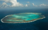

Reserva Biológica Atol das Rocas
279nm
91°
21 Feb 21
azerty
| Latitude | Longitude | |
| DMS | --- | --- |
| DM | --- | --- |
| DD | --- | --- |


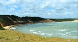
 This is the most important city on the north coast and is also a busy fishing harbour.
Visiting cruisers warn that parts of the city (including areas round the Park Hotel) are not safe, recommending to travel in groups and use a taxi instead of public transport. However, much of Fortaleza is fairly upscale with nice shopping and dining.
Credit card fraud is a problem here, so take extra care if using one.
It is possible to anchor at the commercial harbour on arrival to check in. This anchorage however is not safe and there's no where to leave your dinghy when going ashore. The alternative is to berth at the marina and make the necessary office visits by taxi.
Phone: +55 85 3266 8800
Fax: +55 85 266 5211
Offices are open every day, 24 hours, and cruisers report not being charged overtime on a Saturday.
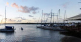
Most visitors moor at the Marina Park Hotel, to the west. A night entry
should be avoided as many boats string lines right across the marina.
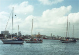
The anchorage off the Yacht Club is reported as unsafe following frequent robberies from yachts anchored there.
Tel:+55 85 263 1744
Fax:+55 85 263 2099
")
")
Ebook | NE Brazil
|