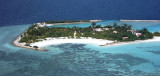
Viligili (Wilingili), a low wooded islet used as a tourist village, lies 1 mile W of Male. It is surrounded by steep-to foul ground extending up to 0.3 mile offshore. The light on the islet is reported to be a good landmark. The channel between Viligili and Male has a 5.5m shoal in the middle, with 11m and 15.4m shoals lying about 0.2 mile and 0.4 mile, respectively, N of it. Tidal currents in this channel are strong and tide rips form near the shoals; navigation of the channel is not recommended.
Funadhoo (Funidu) lies about 0.3 mile N of the E end of Male, and is surrounded by a reef which dries in places. A small tank farm, with three large and about six smaller tanks,stands on the island.
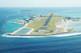
Hulule, about 0.6 mile E of Funadhoo, bears some tall coconut palms; an airstrip runs the full length of the island and joins it to an islet close S. Airport buildings and a small village lie along the central part of the W side of Hulule. The Malé International Airport is located ...
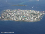
Posée sur les flots, la capitale des Maldives compte 100 000 habitants sur 2 km², soit le tiers de la population du pays. La ville est située sur l'île de Malé d'une superficie de 1,5 km² dans l'atoll de Malé (Kaafu) dans le sud de l'archipel des Maldives. Malé est depuis ...
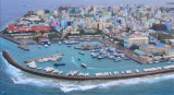
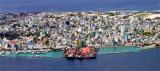
South West Harbor is protected by a rough breakwater of heaped coral extending 0.15 mile from the SW extremity of Male. The harbor is used by inter-island trading boats, cargo lighters, and deep-draft vessels at anchor. The Custom House lies on the main quay facing the main ...
Male, the principal port, is centrally situated at NW corner of Male. Male' Commercial Harbour is situated on the NW side of Male' island. All cargo vessels are handled at Alongside and as well as at anchorage using Barge operation. Most of the container ships are handled at Alongside ...
Feydhoofinolhu, a bare sandy islet, surrounded by a steep-to reef which dries in places, lies 2.3 miles N of Viligili. Breakwaters extend from the islet.Galu Falhu, a circular reef about 1 mile SE of Feydhoofinolhu, appears to contain deep water.


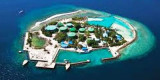


 Viligili (Wilingili), a low wooded islet used as a tourist village, lies 1 mile W of Male. It is surrounded by steep-to foul ground extending up to 0.3 mile offshore.
")
")