Funadhoo (Funidu) lies about 0.3 mile N of the E end of Male, and is surrounded by a reef which dries in places. A small tank farm, with three large and about six smaller tanks,stands on the island.
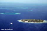
Himmafushi, inhabited, and Lankanfinolhu (Lankanfushifinolhu), about 1.8 miles SW, lie on the same reef, with a low islet about midway between. Himmafushi is a fishing village.Lankanfinolhu houses Paradise island resort. On the outer reef, southeast of the island, there are two ...
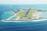
Hulule, about 0.6 mile E of Funadhoo, bears some tall coconut palms; an airstrip runs the full length of the island and joins it to an islet close S. Airport buildings and a small village lie along the central part of the W side of Hulule. The Malé International Airport is located ...
Giraavaru an islet covered in scrub and with a few coconut palms, lies on the SW side of Male Atoll, about 0.5 mile within the outer edge of the barrier reef. A small bare islet lay at the extremity of the reef extending 1 mile W of Giravaru; a similar islet lies 1 mile S of Giravaru. It's ...
A good, easily discernible channel, S of Giravaru, with a least depth of 48m in its center, leads through the barrier reef. A wider, less deep channel lies NW of Giravaru; a shoal patch, with a least depth of 3.4m, lies in the channel, about 0.7 mile NW of Giravaru, where it broadens ...


")
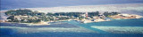
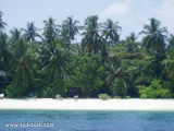
 Cette île, à proximité de Malé, dans un cadre enchanteur, est dotée de tout le confort. La plage de sable est agrémentée de belles petites criques.
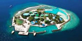
 Furana Fushi, near Malé, host a resort.
the beach has some small creeks.
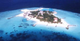
Furana Fushi, near Malé, host a resort.
the beach has some small creeks.