Pulau Batee (S P Nasi)

Pulau Batee (S P Nasi)

Para ubicar con precisión. Actualizar si es necesario.

Ubicación

Pulau Batee (S P Nasi)
LatitudeLongitude
DMS------
DM------
DD------

Característica

Isla / Atoll
Playa
Arena
Buceo
Pesca

Descripción

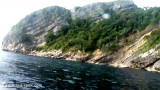
Pulau Batee, lying about 1 mile NE of the E end of Pulau Bunta, is mostly wooded, and rises to 129m.
The island is long and narrow. The mountain range runs along its NE side.
Pulau Batee is borded at its E side by Pulau Lumpai and at the W side, by Pulau Usamlakoh .

The spectacular scenery and abundance of marine life make Pulau Batee a favourite spot for divers.
On that island you can enjoy fishing and snorkelling, as well as jungle trekking or explore under water caves.

The flood sets E from about LW to about HW at rates of from 3.5 to 4 knots and the ebb W at rates of 4.5 to 5 knots. The ebb is usually of longer duration than the flood and there is but little slack water. At neap tides and also during the Northeast Monsoon there is little or no or flood or ebb current.

A dangerous eddy is off Lumpat; when combined with the tidal current between Pulau Bunta and Pulau Batee, it can cause a confused sea. Sometimes this assumes the character of a whirlpool.

2012/01/12
Actualizar
Jojo
Pulau Batee (S P Nasi)
2012-01-12
Actualizar
Jojo
Ebook

Andaman sea

  • 178 sites
  • 164 photos
  • publication date: 7 Jul 2023
  • .pdf file size: 54 Mb
Comparta sus comentarios o fotos en "Pulau Batee (S P Nasi)"

Sitios alrededor de Pulau Batee (S P Nasi)

Flying distances - Direct line

Pulau Peunasoe (Nasi) (SE Breueh)

3.7nm
314°
Pulau Nasi (Peunasoe or Aceh island), nearly joins the SE point of Pulau Breueh, being separated by Aroih Lam Puyang.
The coast line is rocky in places with sandy beaches chiefly on the W side.
11 Jan 12
Jojo

Pulau Bunta (S P Nasi)

2.5nm
236°
Pulau Bunta (Pulau Boenta) lies between Aroih Raya and Aroih Cut (Aroih Tjoet).
Pulo Bunta is the least interesting of the bigger islands in Pulo Aceh. It has a light house and a few beaches, but difficult to swim due to the barrier reefs and strong currents. There are no people ...
19 Jan 12
Jojo

Lhok Prialaut (N Weh)

17nm
14°
Lhok Prialaut is the bay lying between Ug Bau and Ug Seukundo. 6,5 NM appart, between wich points the bay extends S for about 4 NM, with Teluk Sabang on its E shore.
Lhok Prialaut is about 2 miles in length and breadth, with good anchorage near its head, in 16.5 to 21.9m.
Tides—Currents.—The ...
15 Jan 12
Jojo

Aroih Cut (Aroih Tjoet) (S P Batee)

1nm
107°
Aroih Cut (Aroih Tjoet) is funnel-shaped and narrows from about 2 miles in its W entrance to less than 0.2 mile at Ujung Masammuka, with depths of 16.5 to 49.3m.
The flood current sets NE directly through the passage, and the ebb in the opposite direction, at rates of 5 to 6 knots ...
12 Jan 12
Jojo

Aroih Raya (Cedar passage) (SE P Nasi)

1nm
317°
Aroih Raya (Cedar passage) lies between Pulau Nasi on the N and Pulau Bunta (Boenta) and pulau Batee on the S. It is about 1,7 NM wide.
A rock, awash, with sunken rocks N of it, lies about midway between the entrances to Cedar Passage.In Aroih Raya, the current reaches its greatest ...
12 Jan 12
Jojo

Ujung Masammuka (NW Sumatra coast)

1.6nm
99°
Ujung Masammuka ( or Masam Muka) with Ug Raya located 3,5 miles to SSW of it, form the extremity of the island of Sumatra.
Between Masammuka and Ujung Baka, about 14 miles ENE, the coast is rocky and steep for about 1 mile SE of the former, then it is sandy.Except off Ujung Masam ...
17 Jan 12
Jojo