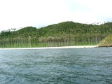
Pulau Bunta (Pulau Boenta) lies between Aroih Raya and Aroih Cut (Aroih Tjoet).
Pulo Bunta is the least interesting of the bigger islands in Pulo Aceh. It
has a light house and a few beaches, but difficult to swim due to the
barrier reefs and strong currents. There are no people living here
except the lighthouse staff.
A vessel approaching from the S should give the W point of Pulau Bunta a berth of at least 1 mile. When the N point of that island bears 090°, pass N, and then NE.
Pulau Nasi (Peunasoe or Aceh island), nearly joins the SE point of Pulau Breueh, being separated by Aroih Lam Puyang. The coast line is rocky in places with sandy beaches chiefly on the W side.
Pulau Batee, lying about 1 mile NE of the E end of Pulau Bunta, is mostly wooded, and rises to 129m. The island is long and narrow. The mountain range runs along its NE side. Pulau Batee is borded at its E side by Pulau Lumpai and at the W side, by Pulau Usamlakoh . The spectacular ...
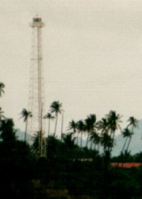
Approx. 40 m square skeletal tower with lantern
and gallery, painted white. This light marks the beginning of
the approach to Banda Aceh from the Indian Ocean.
Ujung Bau (or Baku, Oedjoeng Baoe) is a cape in the region of Aceh, the country of Indonesia with an average elevation of 80 meter above sea level. The location is sparsely populated
Pulau Keureuse (Nasi Kecil) or pulau Teunom, lies about 0.6 mile off the SW end of Pulau Breueh. A sand bank, with depths of less than 5.5m, extends NE for a distance of about 0.3 mile from the NE coast.
Aroih Raya (Cedar passage) lies between Pulau Nasi on the N and Pulau Bunta (Boenta) and pulau Batee on the S. It is about 1,7 NM wide. A rock, awash, with sunken rocks N of it, lies about midway between the entrances to Cedar Passage.In Aroih Raya, the current reaches its greatest ...


 Pulau Bunta (Pulau Boenta) lies between Aroih Raya and Aroih Cut (Aroih Tjoet).
")