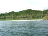
Pulau Peunasoe (Nasi) (SE Breueh)
4.7nm
307°
The coast line is rocky in places with sandy beaches chiefly on the W side.
11 Jan 12
Jojo
| Latitude | Longitude | |
| DMS | --- | --- |
| DM | --- | --- |
| DD | --- | --- |

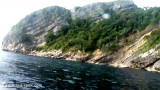
 Aroih Cut (Aroih Tjoet) is funnel-shaped and narrows from about 2 miles in its W entrance to less than 0.2 mile at Ujung Masammuka, with depths of 16.5 to 49.3m.
The flood current sets NE directly through the passage, and the ebb in the opposite direction, at rates of 5 to 6 knots at springs.
In the narrowest part, abreast of Lumpai the eddies make steering difficult.
Depths from 33 to 59m were reported to lie about 3 miles N of Ujung Bau.
Aroih Cut (Aroih Tjoet) may be used by small vessels with a speed of not less than 8 knots.
A vessel approaching from S should steer for Ujung Raya, which is difficult to identify from a distance.
After rounding this point steer for the NE entrance of the strait. A good speed must be maintained when passing through this narrow passage.
A vessel bound W through Aroih Cut (Aroih Tjoet) should steer for the summit of Pulau Bunta, bearing about 247°, passing midway between Ujung Masammuka and Lumpai, then closing the SE shore of the passage, especially during the W currents.
Ebook | Andaman sea
|