Aroih Raya (Cedar passage) lies between Pulau Nasi on the N and Pulau Bunta (Boenta) and pulau Batee on the S. It is about 1,7 NM wide.
A rock, awash, with sunken rocks N of it, lies about midway between the entrances to Cedar Passage.
In Aroih Raya, the current reaches its greatest strength along the N coast of Pulau Batee. Vessels must beware of an eddy at ebb tide flowing due S of the SE point of Pulau Peunasoe and a strong current setting in between the W point of Pulau Batee. Tides rips, at times appearing almost like breakers, form in Aroih Raya and Aroih Cut. They are most violent during the ebb current in the Southwest Monsoon and during the flood in the Northeast Monsoon, that is, with the wind against the current. In the latter season they are comparatively moderate. They are sometimes dangerous to small vessels at anchor in the passages.
Directions.—Aroih Raya should be used only by power vessels because of the strong tidal currents.
Pulau Nasi (Peunasoe or Aceh island), nearly joins the SE point of Pulau Breueh, being separated by Aroih Lam Puyang. The coast line is rocky in places with sandy beaches chiefly on the W side.
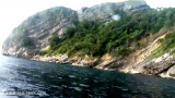
Pulau Batee, lying about 1 mile NE of the E end of Pulau Bunta, is mostly wooded, and rises to 129m. The island is long and narrow. The mountain range runs along its NE side. Pulau Batee is borded at its E side by Pulau Lumpai and at the W side, by Pulau Usamlakoh . The spectacular ...
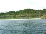
Pulau Bunta (Pulau Boenta) lies between Aroih Raya and Aroih Cut (Aroih Tjoet).
Pulo Bunta is the least interesting of the bigger islands in Pulo Aceh. It
has a light house and a few beaches, but difficult to swim due to the
barrier reefs and strong currents. There are no people ...
Lhok Prialaut is the bay lying between Ug Bau and Ug Seukundo. 6,5 NM appart, between wich points the bay extends S for about 4 NM, with Teluk Sabang on its E shore. Lhok Prialaut is about 2 miles in length and breadth, with good anchorage near its head, in 16.5 to 21.9m. Tides—Currents.—The ...
Ujung Bau (or Baku, Oedjoeng Baoe) is a cape in the region of Aceh, the country of Indonesia with an average elevation of 80 meter above sea level. The location is sparsely populated


 Aroih Raya (Cedar passage) lies between Pulau Nasi on the N and Pulau Bunta (Boenta) and pulau Batee on the S. It is about 1,7 NM wide.