Zeebrugge Port

Zeebrugge Port

To precisely geolocate this site. Update if necessary.

Localisation

Zeebrugge Port
LatitudeLongitude
DMS------
DM------
DD------

Characteristics

Port

Description

Ebook

North sea

  • 102 sites
  • 81 photos
  • publication date: 11 Jul 2023
  • .pdf file size: 78 Mb
Share your comments or photos on "Zeebrugge Port"

Sites around Zeebrugge Port

Flying distances - Direct line

Zeebrugge

1.3nm
168°
Harbor protected by a breakwater.
19 Aug 11
courtneywoods

Oostende

12nm
234°
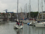
Royal Yacht Club Ostend, the oldest club of Belgium. The city of Oostende with its 9 km of sandy beaches is the biggest and most popular resort of the Belgian coast; The marina is situated at the end of the harbour and has a direct access to the sea and is always accessible whatever ...
5 May 12
Geof

Breskens

14nm
81°
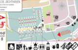
Breskens provides for a stop-over for those who are too tired to already overtake the Westerschelde mouth crossing to Vlissingen (Flushing). Port control is accessible on VHF 14 and the harbour is accessible at all tides. Watch out for the wreck located close to the shore West to ...
17 Aug 16
hetzeilen

Sloehaven

19nm
72°
Commercial harbour. Main industry is the Damen Schelde Naval Shipbuilding (military ships and cargos).
18 Nov 09
cdg2

Oostwatering

20nm
55°
Une alternative a Veere qui l'été est bien souvent surchargé
25 Jul 14
PhGo