YC Porto Rafael (Palau Sardegna)

YC Porto Rafael (Palau Sardegna)

To precisely geolocate this site. Update if necessary.

Localisation

YC Porto Rafael (Palau Sardegna)
LatitudeLongitude
DMS------
DM------
DD------

Characteristics

Port
Mud
Sand
VHF canal 16, 09
Ice
Water
Phone
Electricity
Mechanical repair
Slip
Parking
Shower
Wifi
WC
Market
Restaurant
Lighthouse
Kitesurf
Beach
Sand
Windsurf
Diving
Weather forecast

Description

The small port is located in the Mezzo Schifo bay, between Punta Sardegna and Punta Palau.

Open to NE.

Beware to shoals of Mezzo Passo and of Palau that are indicated.

  • Depth: 3 to 6 m
  • Tel:  0789/700151
  • 70 b incl. 5 transits (<40 m)
  • No shelter when NE winds
2012/09/6
Update
Joëlle
Le petit port est situé dans la rade de Mezzo Schifo, entre Punta Sardegna et Punta Palau.

Ouvert au NE.

Attention aux hauts-fonds de Mezzo Passo et de Palau qui sont bien signalés.

  • Profondeur 3 à 6m.
  • tel: 0789/700151
  • 70 postes dont 5 pour les visiteurs.
  • longueur maxi: 40m
  • Pas protégé des vents NE
2012/09/6
Update
Joëlle
Il porticciolo è situato nella rada di Mezzo Schifo, tra Punta Sardegna e Punta Palau.

Attenzione con venti da NE.

Attenzione alle secche di Mezzo Passo e del Palau che sono ben segnalate.

  • Fondali: 3 a 6m.
  • tel: 0789/700151
  • Posti barca: 70 di cui 5 per il transito.
  • Lunghezza massima: 40m
  • Fare attenzione con venti NE
2012/09/6
Update
Joëlle
YC Porto Rafael (Palau  Sardegna)
2012-09-06
Update
Joëlle
Ebook

Sardegna North East

  • 156 sites
  • 349 photos
  • publication date: 11 Jul 2023
  • .pdf file size: 66 Mb
Ebook

Sardegna

  • 444 sites
  • 1069 photos
  • publication date: 11 Jul 2023
  • .pdf file size: 243 Mb
Share your comments or photos on "YC Porto Rafael (Palau Sardegna)"

Sites around YC Porto Rafael (Palau Sardegna)

Flying distances - Direct line

Isola La Maddalena (Arcipelago della Maddalena)

2.9nm
40°
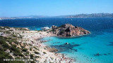
It is the largest island of the archipelago composed of sixty islets and 7 major islands, in the NE end tip of Sardinia. It is mountainous and arid. This is the only inhabited island thoroughly.
It is connected by a bridge to Caprera island where are the house and the tomb of Garibaldi. ...
26 Nov 12
Joëlle

Golfo Di Arzachena (Sardegna)

5.5nm
135°
Gulf of Arzachena (Arsachena), located between Punta Saline and Tre Monti Cape, is a high inlet whose banks are lined with shoals.
S tip, Arzachena, W of the entrance, a beacon consists of an iron post with a sheer spherical white marks a rock particularly ...
8 Sep 12
Joëlle

Golfe de Porto Vecchio

24nm
355°
La tourelle Pecorella marque l'entrée de ce golfe qui s'enfonce à plus de 4 M dans les terres. Celle de Chiapino qui était plus au S est démolie. Il faut donc remonter suffisamment vers le N pour ne pas risquer d'en toucher les restes.
En piquant vers l'W, la balise noire délimite ...
10 Jul 20
azerty

Senetose - Tizzano

32nm
309°
SW of Corsica offers some of the most beautiful anchorages. As you get closer to Bonifacio be carreful with the weather forecast as the NW  wind can be very strong.

The range of the tide in this area is negligible. There are no regular currents along the coasts of Corse, ...
15 May 12
dd

Isola Santa Maria (Arcipelago Maddalena)

6nm
Santa Maria is an island north of the chaplet Razzoli, Budelli and Santa Maria. It has an area of 2 km and a perimeter of ​​about 10 km.

You can anchor in the NW in Cala Muro or SE  in Cala Santa Maria.Santa Maria is separated of Razzoli by the very narrow pass degli ...
25 Nov 12
Joëlle