Waddu Channel, between the S end of Male Atoll and the N end of South Male Atoll, about 2.3 mile S, is very deep and free from dangers.
The tidal currents in the channel are very strong, the flood setting E and the ebb W. During the monsoons, the tidal current accelerated by the prevailing current, setting W during the Northeast Monsoon and E during the Southwest Monsoon, attains a velocity of 4 knots, causing severe tide rips.
Funadhoo (Funidu) lies about 0.3 mile N of the E end of Male, and is surrounded by a reef which dries in places. A small tank farm, with three large and about six smaller tanks,stands on the island.
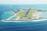
Hulule, about 0.6 mile E of Funadhoo, bears some tall coconut palms; an airstrip runs the full length of the island and joins it to an islet close S. Airport buildings and a small village lie along the central part of the W side of Hulule. The Malé International Airport is located ...
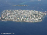
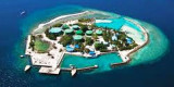
Malé is the capital of the Republic of Maldives located at the southern edge of North Male' Atoll Kaafu. Traditionally it was the King's Island from where the ancient Maldive Royal dynasties ruled and where the palace was located. Formerly it was a walled city surrounded by fortifications ...
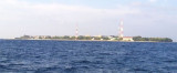
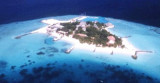
Viligili (Wilingili), a low wooded islet used as a tourist village, lies 1 mile W of Male. It is surrounded by steep-to foul ground extending up to 0.3 mile offshore. The light on the islet is reported to be a good landmark. The channel between Viligili and Male has a 5.5m shoal ...
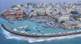
South West Harbor is protected by a rough breakwater of heaped coral extending 0.15 mile from the SW extremity of Male. The harbor is used by inter-island trading boats, cargo lighters, and deep-draft vessels at anchor. The Custom House lies on the main quay facing the main ...
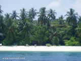
Giraavaru an islet covered in scrub and with a few coconut palms, lies on the SW side of Male Atoll, about 0.5 mile within the outer edge of the barrier reef. A small bare islet lay at the extremity of the reef extending 1 mile W of Giravaru; a similar islet lies 1 mile S of Giravaru. It's ...


 Waddu Channel, between the S end of Male Atoll and the N end of South Male Atoll, about 2.3 mile S, is very deep and free from dangers.