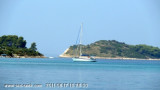
Uvala Duga is located on SE coast of O. Ciovo, NE of O. Fumija.
Sheltered from the breeze of the afternoon. We anchored in about 6 m for lunch. A shallow bank covered by 4 m extends to 0.1 NM E of Rt Rat, the tip S of the bay.
2011/08/19
Update
Croatia
Uvala Duga est située sur la côte SE d'O. Ciovo, au NE d'O. Sv. Fumija.
Abritée de la brise de l'après-midi.
On mouille dans environ 6 m pour le déjeuner.
Un banc peu profond couvert par 4 m s'étend à 0,1 NM à l'E de Rt Rat, la pointe S de la baie.
Ciovo is an island in the center of the Dalmatian archipelago. This is an area of 28.8 acres (15.3 km length, width of 3.5 km). It culminates at 218 m (Mount Rudin). O. Ciovo forms the SW side of the entrance and inner part of Kastelanski Zaliv. At East side, Ciovo is 2km from ...
Island accessible only by sea. It is long about 3 m long by 2 m wide. It is 2 M NW of otok Solta.Its area is 12.07 km ² and its highest point is 178 m.It is separated from the mainland by Drvenicki Kanal. The coast of this beautiful island has remained intact and is made of many ...
Plakeni islands, or Cursed Islands, are located at the W and S of Hvar town.
The islands are rocky, covered with bushes and trees. They are usually deserted, except in summer. They offer many choices of moorings sheltered and there is a marina Palmizana.The islands'name ...
Otok Zirje
is the farthest and the largest island in the Sibenik archipelago. It is long of 6,5 NM (NW/SE) and 1,4 NM wide. The main village, Zirje, is located in the middle of the island. A small port, luka Muna, on the coast N of Zirje, home to the ferry that connects the ...
SV. Fumija is large bay, open W, formed by Island of Ciovo to the North
and two islands on the South, Island of Sv. Fumija and Island of
Kraljevac.Between Island of Sv. Fumija and Island of Ciovo is a shallow bank with
depths of just under 4m over it. Depth is 5.5m between Sv. ...


 Uvala Duga is located on SE coast of O. Ciovo, NE of O. Fumija.
 Uvala Duga est située sur la côte SE d'O. Ciovo, au NE d'O. Sv. Fumija.