Torre di Longosardo (Santa Teresa di Gallura Sardegna)
Latitude
Longitude
DMS
---
---
DM
---
---
DD
---
---
Characteristics
Description
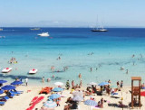
Longosardo tower was built to around XVI century by order of the King of Spain Filipo II. It is situated at the tip that closes to E Rena Bianca cove.
2012/11/23
Update
Joëlle
La tour de Longosardo fut édifiée vers le XVI ème siècle, sur l'ordre du roi d'Espagne Filippo II. Elle est située sur la pointe qui ferme à l'E l'anse de Rena Bianca.
2012/11/23
Update
Joëlle
Torre di Longosardo fu edificata attorno al XVI secolo per ordine del re di Spagna Filipo II. E' situata sulla punta che chiuse all'E la cala di Rena Bianca.
SW of Corsica offers some of the most beautiful anchorages. As you get closer to Bonifacio be carreful with the weather forecast as the NW wind can be very strong.
The range of the tide in this area is negligible. There are no regular currents along the coasts of Corse, ...
It is the largest island of the archipelago composed of sixty islets and 7 major islands, in the NE end tip of Sardinia. It is mountainous and arid. This is the only inhabited island thoroughly. It is connected by a bridge to Caprera island where are the house and the tomb of Garibaldi. ...
La tourelle Pecorella marque l'entrée de ce golfe qui s'enfonce à plus de 4 M dans les terres. Celle de Chiapino qui était plus au S est démolie. Il faut donc remonter suffisamment vers le N pour ne pas risquer d'en toucher les restes. En piquant vers l'W, la balise noire délimite ...
7 MN S Capo Pertusato, in the "Bouches de Bonifacio", is
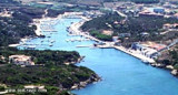
the nearest port when coming from Corsica. Porto Pozzo is a small village in the municipality of Santa Teresa Gallura, the furthest point north of Sardinia, Corsica face. At the time of the Roman Empire, Santa Teresa ...
Gulf of Arzachena (Arsachena), located between Punta Saline and Tre Monti Cape, is a high inlet whose banks are lined with shoals. S tip, Arzachena, W of the entrance, a beacon consists of an iron post with a sheer spherical white marks a rock particularly ...


 Longosardo tower was built to around XVI century by order of the King of Spain Filipo II. It is situated at the tip that closes to E Rena Bianca cove.
 La tour de Longosardo fut édifiée vers le XVI ème siècle, sur l'ordre du roi d'Espagne Filippo II. Elle est située sur la pointe qui ferme à l'E l'anse de Rena Bianca.
 Torre di Longosardo fu edificata attorno al XVI secolo per ordine del re di Spagna Filipo II. E' situata sulla punta che chiuse all'E la cala di Rena Bianca.
")
")
")